Narboneta geodata
Narboneta (Castille-La Mancha) is a seat of a third-order administrative division; located in Spain in Europe/Madrid (GMT+2) time zone. With population of 101 people, there are 5924 cities with bigger population in this country. Compared to other cities in Spain, 73.6% of cities are located further ↑North; 73.3% of cities are located further ←West and 77.1% of cities have lower elevation than Narboneta. Note1
Administrative division(s):
- Level 1: Castille-La Mancha
- Level 2: Provincia de Cuenca
- Level 3: Narboneta


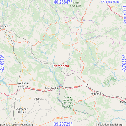
Narboneta GPS coordinates[2]
39° 45' 0" North, 1° 28' 0.012" West
| Map corner | latitude | longitude |
|---|---|---|
| Upper-left | 40.28847°, | -2.16979° |
| Center: | 39.75°, | -1.46667° |
| Lower-right: | 39.20729°, | -0.76354° |
| Map W x H: | 120.2×120.2 km | = 74.7×74.7mi |
| max Lat: | 43.74134° ⇑73.6% North |
| Narboneta: | 39.75° |
| min Lat: | ⇓26.4% South 27.64134° |
| min Long | Narboneta | max Long |
| -18.00367° | -1.46667° | 4.2899° |
| W 73.3%⇐ | ⇒26.7% E |
Elevation
Elevation of Narboneta is 871 m = 2858 ft, and this is 273 m = 896 ft above average elevation for this country.
| Max E: |
1682 m = 5518 ft | 22.9% |
| Narboneta | 871 m 2858 ft | |
| Avg. | 598 m = 1962 ft | |
Min E: |
0 m = 0 ft | 77.1% |
See also: Spain elevation on elevation.city.
Geographical zone
Narboneta is located in North temperate zone (between Tropic of Cancer and the Arctic Circle). Distance of this Northern Tropic circle is 1813.9 km =1127.1 mi to South.| Distance of | km | miles | from Narboneta |
|---|---|---|---|
| North Pole | 5587.3 | 3471.8 | to North |
| Arctic Circle | 2981.4 | 1852.6 | to North |
| Tropic Cancer | 1813.9 | 1127.1 | to South |
| Equator | 4419.8 | 2746.3 | to South |


Nearby cities:
15 places around Narboneta: (largest is in red/bold)
• Aliaguilla
12.1 km =7.5 mi,  94°
94°
• Camporrobles
12.5 km =7.8 mi,  152°
152°
• Cardenete
18.6 km =11.6 mi,  275°
275°
• Enguídanos
14.7 km =9.1 mi,  230°
230°
• Fuentelespino de Moya
18.5 km =11.5 mi,  0°
0°
• Fuenterrobles
21.1 km =13.1 mi, 151°
• Garaballa
11.3 km =7 mi,  49°
49°
• Henarejos
13.1 km =8.1 mi,  353°
353°
• Landete
18.7 km =11.6 mi,  27°
27°
• Mira
4.7 km =2.9 mi,  142°
142°
• San Martín de Boniches
18.7 km =11.6 mi,  332°
332°
• Sinarcas
20 km =12.4 mi,  95°
95°
• Talayuelas
19.2 km =11.9 mi, 54°
• Villar del Humo
19.3 km =12 mi,  312°
312°
• Yémeda
21.4 km =13.3 mi,  274°
274°
Sources, notices
• [Note1] Compared only with cities in Spain existing in our database
• [Src1] Map data: © OpenStreetMap contributors (CC-BY-SA)
• [Src2] Other city data from geonames.org with taken over terms of usage.
• [Src3] Geographical zone / Annual Mean Temperature by Robert A. Rohde @ Wikipedia
