Minglanilla geodata
Minglanilla (Castille-La Mancha) is a seat of a third-order administrative division; located in Spain in Europe/Madrid (GMT+2) time zone. With population of 2,300 people, there are 1998 cities with bigger population in this country. Compared to other cities in Spain, 76.6% of cities are located further ↑North; 72% of cities are located further ←West and 68.6% of cities have lower elevation than Minglanilla. Note1
Administrative division(s):
- Level 1: Castille-La Mancha
- Level 2: Provincia de Cuenca
- Level 3: Minglanilla


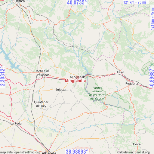
Minglanilla GPS coordinates[2]
39° 31' 59.988" North, 1° 36' 0" West
| Map corner | latitude | longitude |
|---|---|---|
| Upper-left | 40.0735°, | -2.30312° |
| Center: | 39.53333°, | -1.6° |
| Lower-right: | 38.98893°, | -0.89687° |
| Map W x H: | 120.6×120.6 km | = 74.9×74.9mi |
| max Lat: | 43.74134° ⇑76.6% North |
| Minglanilla: | 39.53333° |
| min Lat: | ⇓23.4% South 27.64134° |
| min Long | Minglanilla | max Long |
| -18.00367° | -1.6° | 4.2899° |
| W 72%⇐ | ⇒28% E |
Elevation
Elevation of Minglanilla is 803 m = 2635 ft, and this is 205 m = 673 ft above average elevation for this country.
| Max E: |
1682 m = 5518 ft | 31.4% |
| Minglanilla | 803 m 2635 ft | |
| Avg. | 598 m = 1962 ft | |
Min E: |
0 m = 0 ft | 68.6% |
See also: Spain elevation on elevation.city.
Geographical zone
Minglanilla is located in North temperate zone (between Tropic of Cancer and the Arctic Circle). Distance of this Northern Tropic circle is 1789.8 km =1112.1 mi to South.| Distance of | km | miles | from Minglanilla |
|---|---|---|---|
| North Pole | 5611.4 | 3486.8 | to North |
| Arctic Circle | 3005.5 | 1867.5 | to North |
| Tropic Cancer | 1789.8 | 1112.1 | to South |
| Equator | 4395.7 | 2731.4 | to South |


Nearby cities:
15 places around Minglanilla: (largest is in red/bold)
• Campillo de Altobuey
18.7 km =11.6 mi,  293°
293°
• Camporrobles
21.5 km =13.4 mi,  52°
52°
• Castillejo de Iniesta
14.3 km =8.9 mi,  270°
270°
• El Herrumblar
14.9 km =9.3 mi,  185°
185°
• Enguídanos
14.8 km =9.2 mi,  0°
0°
• Fuenterrobles
22.1 km =13.7 mi,  75°
75°
• Graja de Iniesta
6 km =3.7 mi,  252°
252°
• Iniesta
17 km =10.6 mi,  229°
229°
• Ledaña
20.4 km =12.7 mi,  204°
204°
• Puebla del Salvador
6.8 km =4.2 mi,  302°
302°
• Venta del Moro
22.2 km =13.8 mi,  104°
104°
• Villalpardo
7.9 km =4.9 mi, 201°
• Villamalea
18.6 km =11.6 mi,  175°
175°
• Villargordo del Cabriel
14.3 km =8.9 mi,  90°
90°
• Villarta
10.2 km =6.3 mi, 204°
Sources, notices
• [Note1] Compared only with cities in Spain existing in our database
• [Src1] Map data: © OpenStreetMap contributors (CC-BY-SA)
• [Src2] Other city data from geonames.org with taken over terms of usage.
• [Src3] Geographical zone / Annual Mean Temperature by Robert A. Rohde @ Wikipedia
