Villalpardo geodata
Villalpardo (Castille-La Mancha) is a seat of a third-order administrative division; located in Spain in Europe/Madrid (GMT+2) time zone. With population of 1,153 people, there are 2770 cities with bigger population in this country. Compared to other cities in Spain, 77.2% of cities are located further ↑North; 71.6% of cities are located further ←West and 62.7% of cities have lower elevation than Villalpardo. Note1
Administrative division(s):
- Level 1: Castille-La Mancha
- Level 2: Provincia de Cuenca
- Level 3: Villalpardo


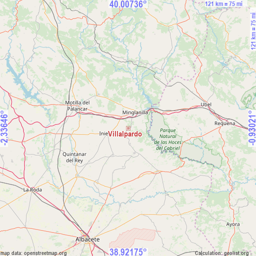
Villalpardo GPS coordinates[2]
39° 28' 0.012" North, 1° 37' 59.988" West
| Map corner | latitude | longitude |
|---|---|---|
| Upper-left | 40.00736°, | -2.33646° |
| Center: | 39.46667°, | -1.63333° |
| Lower-right: | 38.92175°, | -0.93021° |
| Map W x H: | 120.7×120.7 km | = 75×75mi |
| max Lat: | 43.74134° ⇑77.2% North |
| Villalpardo: | 39.46667° |
| min Lat: | ⇓22.8% South 27.64134° |
| min Long | Villalpardo | max Long |
| -18.00367° | -1.63333° | 4.2899° |
| W 71.6%⇐ | ⇒28.4% E |
Elevation
Elevation of Villalpardo is 763 m = 2503 ft, and this is 165 m = 541 ft above average elevation for this country.
| Max E: |
1682 m = 5518 ft | 37.3% |
| Villalpardo | 763 m 2503 ft | |
| Avg. | 598 m = 1962 ft | |
Min E: |
0 m = 0 ft | 62.7% |
See also: Spain elevation on elevation.city.
Geographical zone
Villalpardo is located in North temperate zone (between Tropic of Cancer and the Arctic Circle). Distance of this Northern Tropic circle is 1782.4 km =1107.5 mi to South.| Distance of | km | miles | from Villalpardo |
|---|---|---|---|
| North Pole | 5618.8 | 3491.4 | to North |
| Arctic Circle | 3012.9 | 1872.1 | to North |
| Tropic Cancer | 1782.4 | 1107.5 | to South |
| Equator | 4388.3 | 2726.8 | to South |


Nearby cities:
15 places around Villalpardo: (largest is in red/bold)
• Campillo de Altobuey
20.6 km =12.8 mi,  316°
316°
• Castillejo de Iniesta
13.6 km =8.5 mi,  302°
302°
• Cenizate
18.6 km =11.6 mi,  184°
184°
• El Herrumblar
7.5 km =4.7 mi,  169°
169°
• El Peral
23.2 km =14.4 mi,  279°
279°
• Enguídanos
22.4 km =13.9 mi,  7°
7°
• Graja de Iniesta
6.3 km =3.9 mi,  332°
332°
• Iniesta
10.7 km =6.6 mi,  249°
249°
• Ledaña
12.5 km =7.8 mi,  207°
207°
• Minglanilla
7.9 km =4.9 mi,  21°
21°
• Navas de Jorquera
21.6 km =13.4 mi,  199°
199°
• Puebla del Salvador
11.5 km =7.1 mi,  345°
345°
• Villamalea
11.9 km =7.4 mi,  158°
158°
• Villargordo del Cabriel
18.7 km =11.6 mi,  66°
66°
• Villarta
2.3 km =1.4 mi,  217°
217°
Sources, notices
• [Note1] Compared only with cities in Spain existing in our database
• [Src1] Map data: © OpenStreetMap contributors (CC-BY-SA)
• [Src2] Other city data from geonames.org with taken over terms of usage.
• [Src3] Geographical zone / Annual Mean Temperature by Robert A. Rohde @ Wikipedia
