Manilva geodata
Manilva (Andalusia) is a seat of a third-order administrative division; located in Spain in Europe/Madrid (GMT+2) time zone. With population of 13,813 people, there are 673 cities with bigger population in this country. Compared to other cities in Spain, 98.2% of cities are located further ↑North; 75.7% of cities are located further →East and 85.4% of cities have higher elevation than Manilva. Note1


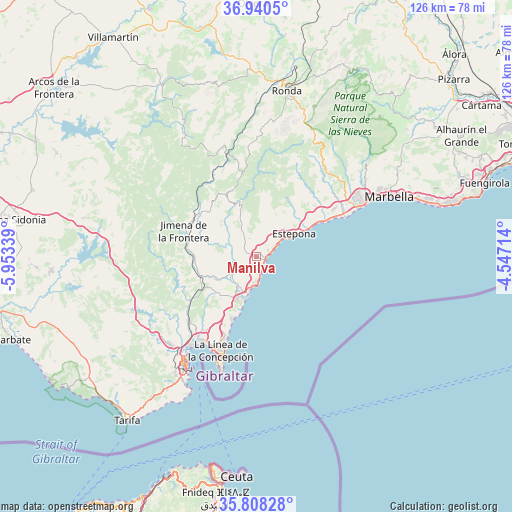
Manilva GPS coordinates[2]
36° 22' 35.22" North, 5° 15' 0.936" West
| Map corner | latitude | longitude |
|---|---|---|
| Upper-left | 36.9405°, | -5.95339° |
| Center: | 36.37645°, | -5.25026° |
| Lower-right: | 35.80828°, | -4.54714° |
| Map W x H: | 125.9×125.9 km | = 78.2×78.2mi |
| max Lat: | 43.74134° ⇑98.2% North |
| Manilva: | 36.37645° |
| min Lat: | ⇓1.8% South 27.64134° |
| min Long | Manilva | max Long |
| -18.00367° | -5.25026° | 4.2899° |
| W 24.3%⇐ | ⇒75.7% E |
Elevation
Elevation of Manilva is 132 m = 433 ft, and this is 466 m = 1529 ft below average elevation for this country.
| Max E: |
1682 m = 5518 ft | 85.4% |
| Avg. | 598 m = 1962 ft | |
| Manilva | 132 m = 433 ft | |
Min E: |
0 m = 0 ft | 14.6% |
See also: Spain elevation on elevation.city.
Geographical zone
Manilva is located in North temperate zone (between Tropic of Cancer and the Arctic Circle). Distance of this Northern Tropic circle is 1438.8 km =894 mi to South.| Distance of | km | miles | from Manilva |
|---|---|---|---|
| North Pole | 5962.4 | 3704.9 | to North |
| Arctic Circle | 3356.5 | 2085.6 | to North |
| Tropic Cancer | 1438.8 | 894 | to South |
| Equator | 4044.7 | 2513.3 | to South |


Nearby cities:
15 places around Manilva: (largest is in red/bold)
• Algatocín
22 km =13.7 mi,  354°
354°
• Benahavís
24.5 km =15.2 mi,  48°
48°
• Benalauría
24.3 km =15.1 mi,  357°
357°
• Benarrabá
19.6 km =12.2 mi, 353°
• Casares
8.5 km =5.3 mi,  337°
337°
• Castellar de la Frontera
19.4 km =12.1 mi,  250°
250°
• Estepona
10.9 km =6.8 mi,  58°
58°
• Gaucín
16.8 km =10.4 mi, 339°
• Genalguacil
18.8 km =11.7 mi,  3°
3°
• Jimena de la Frontera
19.4 km =12.1 mi,  289°
289°
• Jubrique
21.2 km =13.2 mi,  8°
8°
• La Línea de la Concepción
24.8 km =15.4 mi,  200°
200°
• San Enrique de Guadiaro
8.8 km =5.5 mi, 204°
• San Pedro de Alcántara
26.3 km =16.3 mi, 61°
• San Roque
22 km =13.7 mi,  213°
213°
Sources, notices
• [Note1] Compared only with cities in Spain existing in our database
• [Src1] Map data: © OpenStreetMap contributors (CC-BY-SA)
• [Src2] Other city data from geonames.org with taken over terms of usage.
• [Src3] Geographical zone / Annual Mean Temperature by Robert A. Rohde @ Wikipedia
