Benahavís geodata
Benahavís (Andalusia) is a seat of a third-order administrative division; located in Spain in Europe/Madrid (GMT+2) time zone. With population of 2,275 people, there are 2011 cities with bigger population in this country. Compared to other cities in Spain, 98% of cities are located further ↑North; 73.1% of cities are located further →East and 81.9% of cities have higher elevation than Benahavís. Note1


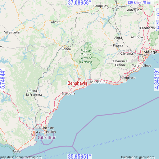
Benahavís GPS coordinates[2]
36° 31' 24.996" North, 5° 2' 46.716" West
| Map corner | latitude | longitude |
|---|---|---|
| Upper-left | 37.08658°, | -5.74944° |
| Center: | 36.52361°, | -5.04631° |
| Lower-right: | 35.95651°, | -4.34319° |
| Map W x H: | 125.7×125.7 km | = 78.1×78.1mi |
| max Lat: | 43.74134° ⇑98% North |
| Benahavís: | 36.52361° |
| min Lat: | ⇓2% South 27.64134° |
| min Long | Benahavís | max Long |
| -18.00367° | -5.04631° | 4.2899° |
| W 26.9%⇐ | ⇒73.1% E |
Elevation
Elevation of Benahavís is 189 m = 620 ft, and this is 409 m = 1342 ft below average elevation for this country.
| Max E: |
1682 m = 5518 ft | 81.9% |
| Avg. | 598 m = 1962 ft | |
| Benahavís | 189 m = 620 ft | |
Min E: |
0 m = 0 ft | 18.1% |
See also: Spain elevation on elevation.city.
Geographical zone
Benahavís is located in North temperate zone (between Tropic of Cancer and the Arctic Circle). Distance of this Northern Tropic circle is 1455.1 km =904.2 mi to South.| Distance of | km | miles | from Benahavís |
|---|---|---|---|
| North Pole | 5946 | 3694.7 | to North |
| Arctic Circle | 3340.1 | 2075.4 | to North |
| Tropic Cancer | 1455.1 | 904.2 | to South |
| Equator | 4061 | 2523.4 | to South |


Nearby cities:
15 places around Benahavís: (largest is in red/bold)
• Alpandeire
18.6 km =11.6 mi,  311°
311°
• Benalauría
20.7 km =12.9 mi,  292°
292°
• Cartajima
16.6 km =10.3 mi,  324°
324°
• Estepona
13.9 km =8.6 mi,  219°
219°
• Faraján
16.4 km =10.2 mi, 309°
• Genalguacil
17.1 km =10.6 mi,  278°
278°
• Igualeja
13.8 km =8.6 mi,  330°
330°
• Istán
10.9 km =6.8 mi,  52°
52°
• Jubrique
15.8 km =9.8 mi, 286°
• Júzcar
15.7 km =9.8 mi, 315°
• Marbella
14.4 km =8.9 mi,  93°
93°
• Ojén
17.6 km =10.9 mi,  74°
74°
• Parauta
16.5 km =10.3 mi, 333°
• Pujerra
13.6 km =8.5 mi, 317°
• San Pedro de Alcántara
6.3 km =3.9 mi,  128°
128°
Sources, notices
• [Note1] Compared only with cities in Spain existing in our database
• [Src1] Map data: © OpenStreetMap contributors (CC-BY-SA)
• [Src2] Other city data from geonames.org with taken over terms of usage.
• [Src3] Geographical zone / Annual Mean Temperature by Robert A. Rohde @ Wikipedia
