San Pedro de Alcántara geodata
San Pedro de Alcántara (Andalusia) is a populated place; located in Spain in Europe/Madrid (GMT+2) time zone. With population of 34,922 people, there are 259 cities with bigger population in this country. Compared to other cities in Spain, 98.1% of cities are located further ↑North; 72.4% of cities are located further →East and 91% of cities have higher elevation than San Pedro de Alcántara. Note1
Current local time in San Pedro de Alcántara:
09:17 PM, ThursdayDifference from your time zone: hours


San Pedro de Alcántara GPS coordinates[2]
36° 29' 18.204" North, 4° 59' 28.428" West
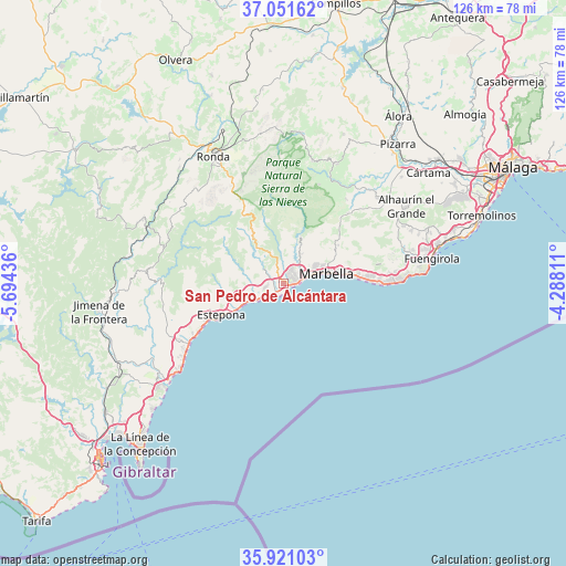
| Map corner | latitude | longitude |
|---|---|---|
| Upper-left | 37.05162°, | -5.69436° |
| Center: | 36.48839°, | -4.99123° |
| Lower-right: | 35.92103°, | -4.28811° |
| Map W x H: | 125.7×125.7 km | = 78.1×78.1mi |
| max Lat: | 43.74134° ⇑98.1% North |
| San Pedro de Alcántara: | 36.48839° |
| min Lat: | ⇓1.9% South 27.64134° |
| min Long | San Pedro de Al | max Long |
| -18.00367° | -4.99123° | 4.2899° |
| W 27.6%⇐ | ⇒72.4% E |
Elevation
Elevation of San Pedro de Alcántara is 52 m = 171 ft, and this is 546 m = 1791 ft below average elevation for this country.
| Max E: |
1682 m = 5518 ft | 91% |
| Avg. | 598 m = 1962 ft | |
| San Pedro de Alcántara | 52 m = 171 ft | |
Min E: |
0 m = 0 ft | 9% |
See also: Spain elevation on elevation.city.
Geographical zone
San Pedro de Alcántara is located in North temperate zone (between Tropic of Cancer and the Arctic Circle). Distance of this Northern Tropic circle is 1451.2 km =901.7 mi to South.| Distance of | km | miles | from San Pedro de Alcántara |
|---|---|---|---|
| North Pole | 5949.9 | 3697.1 | to North |
| Arctic Circle | 3344 | 2077.9 | to North |
| Tropic Cancer | 1451.2 | 901.7 | to South |
| Equator | 4057.1 | 2521 | to South |


Nearby cities:
15 places around San Pedro de Alcántara: (largest is in red/bold)
• Benahavís
6.3 km =3.9 mi,  308°
308°
• Cartajima
22.7 km =14.1 mi,  320°
320°
• Estepona
15.4 km =9.6 mi,  243°
243°
• Faraján
22.7 km =14.1 mi, 309°
• Genalguacil
22.8 km =14.2 mi,  286°
286°
• Guaro
23.3 km =14.5 mi,  36°
36°
• Igualeja
19.8 km =12.3 mi, 323°
• Istán
11.1 km =6.9 mi,  19°
19°
• Jubrique
21.8 km =13.5 mi, 292°
• Júzcar
22 km =13.7 mi, 313°
• Marbella
9.9 km =6.2 mi,  72°
72°
• Monda
21.2 km =13.2 mi, 42°
• Ojén
14.8 km =9.2 mi,  54°
54°
• Parauta
22.4 km =13.9 mi,  326°
326°
• Pujerra
19.8 km =12.3 mi, 314°
Sources, notices
• [Note1] Compared only with cities in Spain existing in our database
• [Src1] Map data: © OpenStreetMap contributors (CC-BY-SA)
• [Src2] Other city data from geonames.org with taken over terms of usage.
• [Src3] Geographical zone / Annual Mean Temperature by Robert A. Rohde @ Wikipedia
