Puerto Lumbreras geodata
Puerto Lumbreras (Murcia) is a populated place; located in Spain in Europe/Madrid (GMT+2) time zone. With population of 13,947 people, there are 664 cities with bigger population in this country. Compared to other cities in Spain, 90.9% of cities are located further ↑North; 69.4% of cities are located further ←West and 63.9% of cities have higher elevation than Puerto Lumbreras. Note1


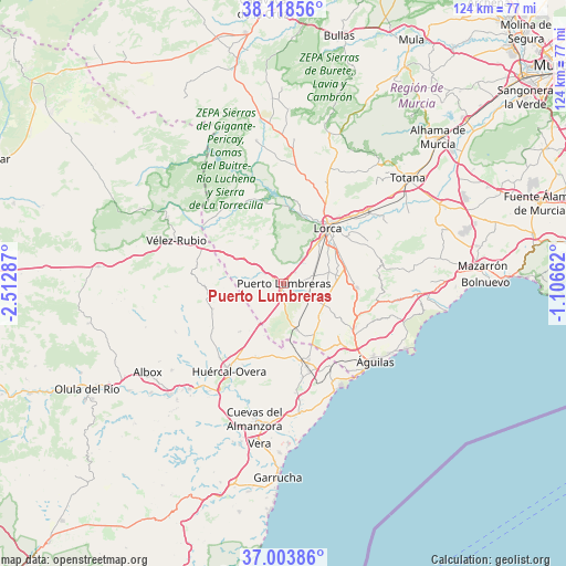
Puerto Lumbreras GPS coordinates[2]
37° 33' 47.844" North, 1° 48' 35.064" West
| Map corner | latitude | longitude |
|---|---|---|
| Upper-left | 38.11856°, | -2.51287° |
| Center: | 37.56329°, | -1.80974° |
| Lower-right: | 37.00386°, | -1.10662° |
| Map W x H: | 123.9×123.9 km | = 77×77mi |
| max Lat: | 43.74134° ⇑90.9% North |
| Puerto Lumbreras: | 37.56329° |
| min Lat: | ⇓9.1% South 27.64134° |
| min Long | Puerto Lumbrera | max Long |
| -18.00367° | -1.80974° | 4.2899° |
| W 69.4%⇐ | ⇒30.6% E |
Elevation
Elevation of Puerto Lumbreras is 475 m = 1558 ft, and this is 123 m = 404 ft below average elevation for this country.
| Max E: |
1682 m = 5518 ft | 63.9% |
| Avg. | 598 m = 1962 ft | |
| Puerto Lumbreras | 475 m = 1558 ft | |
Min E: |
0 m = 0 ft | 36.1% |
See also: Spain elevation on elevation.city.
Geographical zone
Puerto Lumbreras is located in North temperate zone (between Tropic of Cancer and the Arctic Circle). Distance of this Northern Tropic circle is 1570.7 km =976 mi to South.| Distance of | km | miles | from Puerto Lumbreras |
|---|---|---|---|
| North Pole | 5830.4 | 3622.8 | to North |
| Arctic Circle | 3224.5 | 2003.6 | to North |
| Tropic Cancer | 1570.7 | 976 | to South |
| Equator | 4176.6 | 2595.2 | to South |


Nearby cities:
15 places around Puerto Lumbreras: (largest is in red/bold)
• Aledo
33 km =20.5 mi,  39°
39°
• Arboleas
33.2 km =20.6 mi,  224°
224°
• Cazalla
15.7 km =9.8 mi,  52°
52°
• Cuevas del Almanzora
30.3 km =18.8 mi,  192°
192°
• Guazamara
23.8 km =14.8 mi,  174°
174°
• Huércal-Overa
22.7 km =14.1 mi,  211°
211°
• La Torrecilla
9.9 km =6.2 mi, 47°
• Lorca
15.3 km =9.5 mi, 38°
• María
35.3 km =21.9 mi,  297°
297°
• Pulpí
17.8 km =11.1 mi,  161°
161°
• Taberno
25.8 km =16 mi,  246°
246°
• Velez Rubio
25.4 km =15.8 mi,  291°
291°
• Vélez-Blanco
29 km =18 mi, 299°
• Zurgena
31.9 km =19.8 mi, 219°
• Águilas
26.6 km =16.5 mi,  131°
131°
Sources, notices
• [Note1] Compared only with cities in Spain existing in our database
• [Src1] Map data: © OpenStreetMap contributors (CC-BY-SA)
• [Src2] Other city data from geonames.org with taken over terms of usage.
• [Src3] Geographical zone / Annual Mean Temperature by Robert A. Rohde @ Wikipedia
