Águilas geodata
Águilas (Murcia) is a seat of a third-order administrative division; located in Spain in Europe/Madrid (GMT+2) time zone. With population of 34,533 people, there are 262 cities with bigger population in this country. Compared to other cities in Spain, 91.9% of cities are located further ↑North; 72.2% of cities are located further ←West and 95.4% of cities have higher elevation than Águilas. Note1


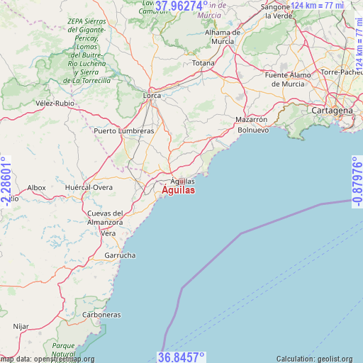
Águilas GPS coordinates[2]
37° 24' 22.68" North, 1° 34' 58.404" West
| Map corner | latitude | longitude |
|---|---|---|
| Upper-left | 37.96274°, | -2.28601° |
| Center: | 37.4063°, | -1.58289° |
| Lower-right: | 36.8457°, | -0.87976° |
| Map W x H: | 124.2×124.2 km | = 77.2×77.2mi |
| max Lat: | 43.74134° ⇑91.9% North |
| Águilas: | 37.4063° |
| min Lat: | ⇓8.1% South 27.64134° |
| min Long | Águilas | max Long |
| -18.00367° | -1.58289° | 4.2899° |
| W 72.2%⇐ | ⇒27.8% E |
Elevation
Elevation of Águilas is 23 m = 75 ft, and this is 575 m = 1886 ft below average elevation for this country.
| Max E: |
1682 m = 5518 ft | 95.4% |
| Avg. | 598 m = 1962 ft | |
| Águilas | 23 m = 75 ft | |
Min E: |
0 m = 0 ft | 4.6% |
See also: Spain elevation on elevation.city.
Geographical zone
Águilas is located in North temperate zone (between Tropic of Cancer and the Arctic Circle). Distance of this Northern Tropic circle is 1553.3 km =965.2 mi to South.| Distance of | km | miles | from Águilas |
|---|---|---|---|
| North Pole | 5847.9 | 3633.7 | to North |
| Arctic Circle | 3242 | 2014.5 | to North |
| Tropic Cancer | 1553.3 | 965.2 | to South |
| Equator | 4159.2 | 2584.4 | to South |


Nearby cities:
15 places around Águilas: (largest is in red/bold)
• Antas
34.6 km =21.5 mi,  238°
238°
• Cazalla
28 km =17.4 mi,  344°
344°
• Cuevas del Almanzora
29.1 km =18.1 mi,  245°
245°
• Garrucha
32.8 km =20.4 mi,  220°
220°
• Guazamara
18.8 km =11.7 mi, 250°
• Huércal-Overa
31.9 km =19.8 mi,  266°
266°
• La Torrecilla
27.3 km =17 mi,  332°
332°
• Lorca
31.3 km =19.4 mi, 340°
• Mazarrón
31.9 km =19.8 mi,  47°
47°
• Mojacar
37.9 km =23.5 mi, 218°
• Puerto Lumbreras
26.6 km =16.5 mi,  311°
311°
• Pulpí
14.3 km =8.9 mi, 272°
• Totana
40.9 km =25.4 mi,  9°
9°
• Turre
39.5 km =24.5 mi, 224°
• Vera
30.4 km =18.9 mi,  233°
233°
Sources, notices
• [Note1] Compared only with cities in Spain existing in our database
• [Src1] Map data: © OpenStreetMap contributors (CC-BY-SA)
• [Src2] Other city data from geonames.org with taken over terms of usage.
• [Src3] Geographical zone / Annual Mean Temperature by Robert A. Rohde @ Wikipedia
