Arboleas geodata
Arboleas (Andalusia) is a seat of a third-order administrative division; located in Spain in Europe/Madrid (GMT+2) time zone. With population of 2,614 people, there are 1857 cities with bigger population in this country. Compared to other cities in Spain, 92.5% of cities are located further ↑North; 66.6% of cities are located further ←West and 75% of cities have higher elevation than Arboleas. Note1


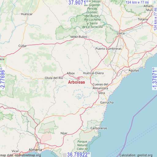
Arboleas GPS coordinates[2]
37° 21' 0.864" North, 2° 4' 25.824" West
| Map corner | latitude | longitude |
|---|---|---|
| Upper-left | 37.9071°, | -2.77696° |
| Center: | 37.35024°, | -2.07384° |
| Lower-right: | 36.78922°, | -1.37071° |
| Map W x H: | 124.3×124.3 km | = 77.2×77.2mi |
| max Lat: | 43.74134° ⇑92.5% North |
| Arboleas: | 37.35024° |
| min Lat: | ⇓7.5% South 27.64134° |
| min Long | Arboleas | max Long |
| -18.00367° | -2.07384° | 4.2899° |
| W 66.6%⇐ | ⇒33.4% E |
Elevation
Elevation of Arboleas is 296 m = 971 ft, and this is 302 m = 991 ft below average elevation for this country.
| Max E: |
1682 m = 5518 ft | 75% |
| Avg. | 598 m = 1962 ft | |
| Arboleas | 296 m = 971 ft | |
Min E: |
0 m = 0 ft | 25% |
See also: Spain elevation on elevation.city.
Geographical zone
Arboleas is located in North temperate zone (between Tropic of Cancer and the Arctic Circle). Distance of this Northern Tropic circle is 1547 km =961.3 mi to South.| Distance of | km | miles | from Arboleas |
|---|---|---|---|
| North Pole | 5854.1 | 3637.6 | to North |
| Arctic Circle | 3248.2 | 2018.3 | to North |
| Tropic Cancer | 1547 | 961.3 | to South |
| Equator | 4153 | 2580.6 | to South |


Nearby cities:
15 places around Arboleas: (largest is in red/bold)
• Albox
7.9 km =4.9 mi,  302°
302°
• Albánchez
12.1 km =7.5 mi,  232°
232°
• Antas
18.1 km =11.2 mi,  130°
130°
• Benitagla
19.7 km =12.2 mi, 227°
• Bédar
19.2 km =11.9 mi,  154°
154°
• Cantoria
10.5 km =6.5 mi,  270°
270°
• Cuevas del Almanzora
18 km =11.2 mi,  109°
109°
• Cóbdar
15.6 km =9.7 mi, 230°
• Fines
16.3 km =10.1 mi, 274°
• Huércal-Overa
12.3 km =7.6 mi,  69°
69°
• Lubrín
15 km =9.3 mi,  177°
177°
• Olula del Río
19.8 km =12.3 mi, 271°
• Partaloa
14.8 km =9.2 mi, 295°
• Taberno
13.2 km =8.2 mi,  358°
358°
• Zurgena
3.1 km =1.9 mi, 106°
Sources, notices
• [Note1] Compared only with cities in Spain existing in our database
• [Src1] Map data: © OpenStreetMap contributors (CC-BY-SA)
• [Src2] Other city data from geonames.org with taken over terms of usage.
• [Src3] Geographical zone / Annual Mean Temperature by Robert A. Rohde @ Wikipedia
