Lugros geodata
Lugros (Andalusia) is a seat of a third-order administrative division; located in Spain in Europe/Madrid (GMT+2) time zone. With population of 366 people, there are 4257 cities with bigger population in this country. Compared to other cities in Spain, 93.7% of cities are located further ↑North; 51.1% of cities are located further ←West and 98% of cities have lower elevation than Lugros. Note1


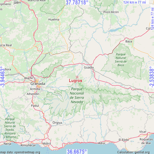
Lugros GPS coordinates[2]
37° 13' 45.912" North, 3° 14' 29.4" West
| Map corner | latitude | longitude |
|---|---|---|
| Upper-left | 37.78718°, | -3.94463° |
| Center: | 37.22942°, | -3.2415° |
| Lower-right: | 36.6675°, | -2.53838° |
| Map W x H: | 124.5×124.5 km | = 77.4×77.4mi |
| max Lat: | 43.74134° ⇑93.7% North |
| Lugros: | 37.22942° |
| min Lat: | ⇓6.3% South 27.64134° |
| min Long | Lugros | max Long |
| -18.00367° | -3.2415° | 4.2899° |
| W 51.1%⇐ | ⇒48.9% E |
Elevation
Elevation of Lugros is 1253 m = 4111 ft, and this is 655 m = 2149 ft above average elevation for this country.
| Max E: |
1682 m = 5518 ft | 2% |
| Lugros | 1253 m 4111 ft | |
| Avg. | 598 m = 1962 ft | |
Min E: |
0 m = 0 ft | 98% |
See also: Spain elevation on elevation.city.
Geographical zone
Lugros is located in North temperate zone (between Tropic of Cancer and the Arctic Circle). Distance of this Northern Tropic circle is 1533.6 km =952.9 mi to South.| Distance of | km | miles | from Lugros |
|---|---|---|---|
| North Pole | 5867.5 | 3645.9 | to North |
| Arctic Circle | 3261.7 | 2026.7 | to North |
| Tropic Cancer | 1533.6 | 952.9 | to South |
| Equator | 4139.5 | 2572.2 | to South |


Nearby cities:
15 places around Lugros: (largest is in red/bold)
• Albuñán
9.6 km =6 mi,  91°
91°
• Aldeire
16.9 km =10.5 mi,  117°
117°
• Alquife
12.4 km =7.7 mi, 116°
• Beas de Guadix
6.3 km =3.9 mi,  30°
30°
• Benalúa de Guadix
15.2 km =9.4 mi, 26°
• Cogollos de Guadix
7.1 km =4.4 mi, 93°
• Darro
14.2 km =8.8 mi,  340°
340°
• Diezma
12.9 km =8 mi,  321°
321°
• Guadix
11.9 km =7.4 mi,  49°
49°
• Güéjar-Sierra
19.1 km =11.9 mi,  246°
246°
• Jérez del Marquesado
8.8 km =5.5 mi, 124°
• Lanteira
11.4 km =7.1 mi,  126°
126°
• Marchal
8.2 km =5.1 mi,  24°
24°
• Polícar
3.2 km =2 mi,  12°
12°
• Purullena
10.8 km =6.7 mi, 24°
Sources, notices
• [Note1] Compared only with cities in Spain existing in our database
• [Src1] Map data: © OpenStreetMap contributors (CC-BY-SA)
• [Src2] Other city data from geonames.org with taken over terms of usage.
• [Src3] Geographical zone / Annual Mean Temperature by Robert A. Rohde @ Wikipedia
