Los Yébenes geodata
Los Yébenes (Castille-La Mancha) is a populated place; located in Spain in Europe/Madrid (GMT+2) time zone. With population of 6,224 people, there are 1111 cities with bigger population in this country. Compared to other cities in Spain, 75.9% of cities are located further ↑North; 57.8% of cities are located further →East and 71.3% of cities have lower elevation than Los Yébenes. Note1
Administrative division(s):
- Level 1: Castille-La Mancha
- Level 2: Province of Toledo
- Level 3: Yébenes, Los


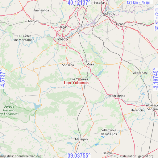
Los Yébenes GPS coordinates[2]
39° 34' 53.688" North, 3° 52' 14.088" West
| Map corner | latitude | longitude |
|---|---|---|
| Upper-left | 40.12137°, | -4.5737° |
| Center: | 39.58158°, | -3.87058° |
| Lower-right: | 39.03755°, | -3.16745° |
| Map W x H: | 120.5×120.5 km | = 74.9×74.9mi |
| max Lat: | 43.74134° ⇑75.9% North |
| Los Yébenes: | 39.58158° |
| min Lat: | ⇓24.1% South 27.64134° |
| min Long | Los Yébenes | max Long |
| -18.00367° | -3.87058° | 4.2899° |
| W 42.2%⇐ | ⇒57.8% E |
Elevation
Elevation of Los Yébenes is 823 m = 2700 ft, and this is 225 m = 738 ft above average elevation for this country.
| Max E: |
1682 m = 5518 ft | 28.7% |
| Los Yébenes | 823 m 2700 ft | |
| Avg. | 598 m = 1962 ft | |
Min E: |
0 m = 0 ft | 71.3% |
See also: Spain elevation on elevation.city.
Geographical zone
Los Yébenes is located in North temperate zone (between Tropic of Cancer and the Arctic Circle). Distance of this Northern Tropic circle is 1795.1 km =1115.4 mi to South.| Distance of | km | miles | from Los Yébenes |
|---|---|---|---|
| North Pole | 5606 | 3483.4 | to North |
| Arctic Circle | 3000.1 | 1864.2 | to North |
| Tropic Cancer | 1795.1 | 1115.4 | to South |
| Equator | 4401.1 | 2734.7 | to South |


Nearby cities:
15 places around Los Yébenes: (largest is in red/bold)
• Ajofrín
17.3 km =10.7 mi,  326°
326°
• Almonacid de Toledo
19.3 km =12 mi,  4°
4°
• Chueca
17.8 km =11.1 mi,  339°
339°
• Manzaneque
9 km =5.6 mi,  48°
48°
• Marjaliza
5.9 km =3.7 mi,  249°
249°
• Mascaraque
15.8 km =9.8 mi,  18°
18°
• Mazarambroz
17.9 km =11.1 mi,  314°
314°
• Mora
14.2 km =8.8 mi,  35°
35°
• Nambroca
24.8 km =15.4 mi,  345°
345°
• Orgaz
7.4 km =4.6 mi,  356°
356°
• Sonseca
13.9 km =8.6 mi,  320°
320°
• Turleque
22.1 km =13.7 mi,  84°
84°
• Urda
23.1 km =14.4 mi,  144°
144°
• Villaminaya
14.5 km =9 mi, 0°
• Villanueva de Bogas
24.1 km =15 mi, 49°
Sources, notices
• [Note1] Compared only with cities in Spain existing in our database
• [Src1] Map data: © OpenStreetMap contributors (CC-BY-SA)
• [Src2] Other city data from geonames.org with taken over terms of usage.
• [Src3] Geographical zone / Annual Mean Temperature by Robert A. Rohde @ Wikipedia
