Nambroca geodata
Nambroca (Castille-La Mancha) is a seat of a third-order administrative division; located in Spain in Europe/Madrid (GMT+2) time zone. With population of 2,920 people, there are 1750 cities with bigger population in this country. Compared to other cities in Spain, 72.9% of cities are located further ↑North; 58.9% of cities are located further →East and 52% of cities have lower elevation than Nambroca. Note1
Administrative division(s):
- Level 1: Castille-La Mancha
- Level 2: Province of Toledo
- Level 3: Nambroca


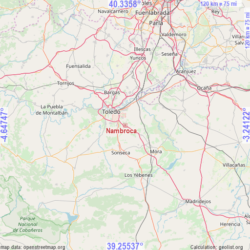
Nambroca GPS coordinates[2]
39° 47' 51.756" North, 3° 56' 39.624" West
| Map corner | latitude | longitude |
|---|---|---|
| Upper-left | 40.3358°, | -4.64747° |
| Center: | 39.79771°, | -3.94434° |
| Lower-right: | 39.25537°, | -3.24122° |
| Map W x H: | 120.1×120.1 km | = 74.6×74.6mi |
| max Lat: | 43.74134° ⇑72.9% North |
| Nambroca: | 39.79771° |
| min Lat: | ⇓27.1% South 27.64134° |
| min Long | Nambroca | max Long |
| -18.00367° | -3.94434° | 4.2899° |
| W 41.1%⇐ | ⇒58.9% E |
Elevation
Elevation of Nambroca is 680 m = 2231 ft, and this is 82 m = 269 ft above average elevation for this country.
| Max E: |
1682 m = 5518 ft | 48% |
| Nambroca | 680 m 2231 ft | |
| Avg. | 598 m = 1962 ft | |
Min E: |
0 m = 0 ft | 52% |
See also: Spain elevation on elevation.city.
Geographical zone
Nambroca is located in North temperate zone (between Tropic of Cancer and the Arctic Circle). Distance of this Northern Tropic circle is 1819.2 km =1130.4 mi to South.| Distance of | km | miles | from Nambroca |
|---|---|---|---|
| North Pole | 5582 | 3468.5 | to North |
| Arctic Circle | 2976.1 | 1849.3 | to North |
| Tropic Cancer | 1819.2 | 1130.4 | to South |
| Equator | 4425.1 | 2749.6 | to South |


Nearby cities:
15 places around Nambroca: (largest is in red/bold)
• Ajofrín
10.2 km =6.3 mi,  198°
198°
• Almonacid de Toledo
9.2 km =5.7 mi,  121°
121°
• Bargas
17.2 km =10.7 mi,  338°
338°
• Burguillos de Toledo
4.1 km =2.5 mi,  267°
267°
• Casasbuenas
16 km =9.9 mi,  255°
255°
• Chueca
7.3 km =4.5 mi,  179°
179°
• Cobisa
7 km =4.3 mi,  276°
276°
• Layos
10.5 km =6.5 mi, 257°
• Mascaraque
14.4 km =8.9 mi,  128°
128°
• Mazarambroz
13.2 km =8.2 mi,  209°
209°
• Mocejón
15.9 km =9.9 mi,  8°
8°
• Olías del Rey
16.7 km =10.4 mi,  347°
347°
• Sonseca
13.6 km =8.5 mi,  190°
190°
• Toledo
9.5 km =5.9 mi,  315°
315°
• Villaminaya
11.4 km =7.1 mi,  146°
146°
Sources, notices
• [Note1] Compared only with cities in Spain existing in our database
• [Src1] Map data: © OpenStreetMap contributors (CC-BY-SA)
• [Src2] Other city data from geonames.org with taken over terms of usage.
• [Src3] Geographical zone / Annual Mean Temperature by Robert A. Rohde @ Wikipedia
