Chueca geodata
Chueca (Castille-La Mancha) is a seat of a third-order administrative division; located in Spain in Europe/Madrid (GMT+2) time zone. With population of 228 people, there are 4870 cities with bigger population in this country. Compared to other cities in Spain, 73.8% of cities are located further ↑North; 58.9% of cities are located further →East and 59.2% of cities have lower elevation than Chueca. Note1


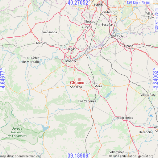
Chueca GPS coordinates[2]
39° 43' 54.876" North, 3° 56' 37.14" West
| Map corner | latitude | longitude |
|---|---|---|
| Upper-left | 40.27052°, | -4.64677° |
| Center: | 39.73191°, | -3.94365° |
| Lower-right: | 39.18906°, | -3.24052° |
| Map W x H: | 120.2×120.2 km | = 74.7×74.7mi |
| max Lat: | 43.74134° ⇑73.8% North |
| Chueca: | 39.73191° |
| min Lat: | ⇓26.2% South 27.64134° |
| min Long | Chueca | max Long |
| -18.00367° | -3.94365° | 4.2899° |
| W 41.1%⇐ | ⇒58.9% E |
Elevation
Elevation of Chueca is 739 m = 2425 ft, and this is 141 m = 463 ft above average elevation for this country.
| Max E: |
1682 m = 5518 ft | 40.8% |
| Chueca | 739 m 2425 ft | |
| Avg. | 598 m = 1962 ft | |
Min E: |
0 m = 0 ft | 59.2% |
See also: Spain elevation on elevation.city.
Geographical zone
Chueca is located in North temperate zone (between Tropic of Cancer and the Arctic Circle). Distance of this Northern Tropic circle is 1811.9 km =1125.9 mi to South.| Distance of | km | miles | from Chueca |
|---|---|---|---|
| North Pole | 5589.3 | 3473 | to North |
| Arctic Circle | 2983.4 | 1853.8 | to North |
| Tropic Cancer | 1811.9 | 1125.9 | to South |
| Equator | 4417.8 | 2745.1 | to South |


Nearby cities:
15 places around Chueca: (largest is in red/bold)
• Ajofrín
4 km =2.5 mi,  234°
234°
• Almonacid de Toledo
8.2 km =5.1 mi,  72°
72°
• Burguillos de Toledo
8.3 km =5.2 mi,  329°
329°
• Casasbuenas
15.9 km =9.9 mi,  281°
281°
• Cobisa
10.6 km =6.6 mi,  319°
319°
• Layos
11.5 km =7.1 mi,  295°
295°
• Manzaneque
16.8 km =10.4 mi,  129°
129°
• Mascaraque
11.3 km =7 mi,  98°
98°
• Mazarambroz
7.7 km =4.8 mi,  237°
237°
• Mora
15.4 km =9.6 mi,  109°
109°
• Nambroca
7.3 km =4.5 mi,  359°
359°
• Orgaz
11 km =6.8 mi,  148°
148°
• Sonseca
6.6 km =4.1 mi,  203°
203°
• Toledo
15.6 km =9.7 mi, 334°
• Villaminaya
6.6 km =4.1 mi, 109°
Sources, notices
• [Note1] Compared only with cities in Spain existing in our database
• [Src1] Map data: © OpenStreetMap contributors (CC-BY-SA)
• [Src2] Other city data from geonames.org with taken over terms of usage.
• [Src3] Geographical zone / Annual Mean Temperature by Robert A. Rohde @ Wikipedia
