Urda geodata
Urda (Castille-La Mancha) is a seat of a third-order administrative division; located in Spain in Europe/Madrid (GMT+2) time zone. With population of 3,123 people, there are 1684 cities with bigger population in this country. Compared to other cities in Spain, 77.7% of cities are located further ↑North; 55.6% of cities are located further →East and 63.8% of cities have lower elevation than Urda. Note1


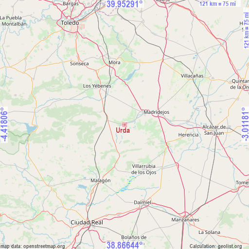
Urda GPS coordinates[2]
39° 24' 42.444" North, 3° 42' 53.748" West
| Map corner | latitude | longitude |
|---|---|---|
| Upper-left | 39.95291°, | -4.41806° |
| Center: | 39.41179°, | -3.71493° |
| Lower-right: | 38.86644°, | -3.01181° |
| Map W x H: | 120.8×120.8 km | = 75.1×75.1mi |
| max Lat: | 43.74134° ⇑77.7% North |
| Urda: | 39.41179° |
| min Lat: | ⇓22.3% South 27.64134° |
| min Long | Urda | max Long |
| -18.00367° | -3.71493° | 4.2899° |
| W 44.4%⇐ | ⇒55.6% E |
Elevation
Elevation of Urda is 770 m = 2526 ft, and this is 172 m = 564 ft above average elevation for this country.
| Max E: |
1682 m = 5518 ft | 36.2% |
| Urda | 770 m 2526 ft | |
| Avg. | 598 m = 1962 ft | |
Min E: |
0 m = 0 ft | 63.8% |
See also: Spain elevation on elevation.city.
Geographical zone
Urda is located in North temperate zone (between Tropic of Cancer and the Arctic Circle). Distance of this Northern Tropic circle is 1776.3 km =1103.7 mi to South.| Distance of | km | miles | from Urda |
|---|---|---|---|
| North Pole | 5624.9 | 3495.1 | to North |
| Arctic Circle | 3019 | 1875.9 | to North |
| Tropic Cancer | 1776.3 | 1103.7 | to South |
| Equator | 4382.2 | 2723 | to South |


Nearby cities:
15 places around Urda: (largest is in red/bold)
• Arenas de San Juan
28.2 km =17.5 mi,  139°
139°
• Ballesteros
26.3 km =16.3 mi,  234°
234°
• Camuñas
22.4 km =13.9 mi,  85°
85°
• Consuegra
10.8 km =6.7 mi,  58°
58°
• Fuente el Fresno
21 km =13 mi,  194°
194°
• Las Labores
22.7 km =14.1 mi,  132°
132°
• Los Yébenes
23.1 km =14.4 mi,  324°
324°
• Madridejos
16.9 km =10.5 mi,  68°
68°
• Malagón
29.8 km =18.5 mi,  203°
203°
• Manzaneque
25.7 km =16 mi,  345°
345°
• Marjaliza
25.3 km =15.7 mi,  311°
311°
• Orgaz
29.7 km =18.5 mi,  332°
332°
• Puerto Lápice
22.3 km =13.9 mi,  116°
116°
• Turleque
22.8 km =14.2 mi,  22°
22°
• Villarrubia de los Ojos
23.1 km =14.4 mi,  156°
156°
Sources, notices
• [Note1] Compared only with cities in Spain existing in our database
• [Src1] Map data: © OpenStreetMap contributors (CC-BY-SA)
• [Src2] Other city data from geonames.org with taken over terms of usage.
• [Src3] Geographical zone / Annual Mean Temperature by Robert A. Rohde @ Wikipedia
