Llaurí geodata
Llaurí (Valencia) is a seat of a third-order administrative division; located in Spain in Europe/Madrid (GMT+2) time zone. With population of 1,269 people, there are 2669 cities with bigger population in this country. Compared to other cities in Spain, 79.8% of cities are located further ↑North; 84.2% of cities are located further ←West and 96.2% of cities have higher elevation than Llaurí. Note1


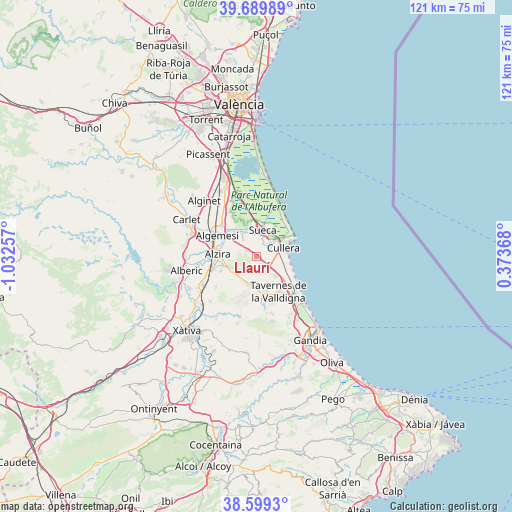
Llaurí GPS coordinates[2]
39° 8' 48.156" North, 0° 19' 45.984" West
| Map corner | latitude | longitude |
|---|---|---|
| Upper-left | 39.68989°, | -1.03257° |
| Center: | 39.14671°, | -0.32944° |
| Lower-right: | 38.5993°, | 0.37368° |
| Map W x H: | 121.3×121.3 km | = 75.4×75.4mi |
| max Lat: | 43.74134° ⇑79.8% North |
| Llaurí: | 39.14671° |
| min Lat: | ⇓20.2% South 27.64134° |
| min Long | Llaurí | max Long |
| -18.00367° | -0.32944° | 4.2899° |
| W 84.2%⇐ | ⇒15.8% E |
Elevation
Elevation of Llaurí is 19 m = 62 ft, and this is 579 m = 1900 ft below average elevation for this country.
| Max E: |
1682 m = 5518 ft | 96.2% |
| Avg. | 598 m = 1962 ft | |
| Llaurí | 19 m = 62 ft | |
Min E: |
0 m = 0 ft | 3.8% |
See also: Spain elevation on elevation.city.
Geographical zone
Llaurí is located in North temperate zone (between Tropic of Cancer and the Arctic Circle). Distance of this Northern Tropic circle is 1746.8 km =1085.4 mi to South.| Distance of | km | miles | from Llaurí |
|---|---|---|---|
| North Pole | 5654.4 | 3513.5 | to North |
| Arctic Circle | 3048.5 | 1894.2 | to North |
| Tropic Cancer | 1746.8 | 1085.4 | to South |
| Equator | 4352.7 | 2704.6 | to South |


Nearby cities:
15 places around Llaurí: (largest is in red/bold)
• Albalat de la Ribera
7.5 km =4.7 mi,  321°
321°
• Algemesí
10.4 km =6.5 mi,  297°
297°
• Alzira
9 km =5.6 mi,  272°
272°
• Benicull de Xúquer
6.2 km =3.9 mi,  311°
311°
• Carcaixent
10.6 km =6.6 mi,  254°
254°
• Corbera
1.8 km =1.1 mi,  281°
281°
• Cullera
7.2 km =4.5 mi,  72°
72°
• Favara
5.2 km =3.2 mi,  130°
130°
• Fortaleny
4.8 km =3 mi,  31°
31°
• Guadassuar
13.6 km =8.5 mi,  289°
289°
• Polinyà de Xúquer
6.7 km =4.2 mi,  331°
331°
• Riola
5.9 km =3.7 mi,  356°
356°
• Simat de la Valldigna
12.7 km =7.9 mi,  175°
175°
• Sueca
6.4 km =4 mi,  14°
14°
• Tavernes de la Valldigna
9.9 km =6.2 mi,  146°
146°
Sources, notices
• [Note1] Compared only with cities in Spain existing in our database
• [Src1] Map data: © OpenStreetMap contributors (CC-BY-SA)
• [Src2] Other city data from geonames.org with taken over terms of usage.
• [Src3] Geographical zone / Annual Mean Temperature by Robert A. Rohde @ Wikipedia
