Alzira geodata
Alzira (Valencia) is a seat of a third-order administrative division; located in Spain in Europe/Madrid (GMT+2) time zone. With population of 44,690 people, there are 194 cities with bigger population in this country. Compared to other cities in Spain, 79.8% of cities are located further ↑North; 82.6% of cities are located further ←West and 94.7% of cities have higher elevation than Alzira. Note1


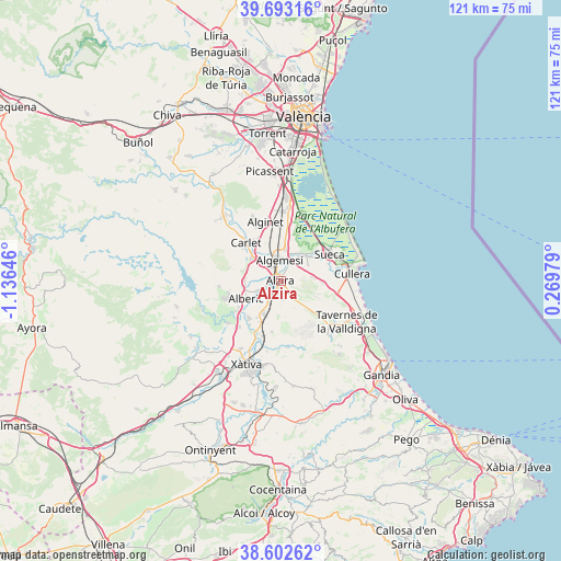
Alzira GPS coordinates[2]
39° 9' 0" North, 0° 25' 59.988" West
| Map corner | latitude | longitude |
|---|---|---|
| Upper-left | 39.69316°, | -1.13646° |
| Center: | 39.15°, | -0.43333° |
| Lower-right: | 38.60262°, | 0.26979° |
| Map W x H: | 121.3×121.3 km | = 75.4×75.4mi |
| max Lat: | 43.74134° ⇑79.8% North |
| Alzira: | 39.15° |
| min Lat: | ⇓20.2% South 27.64134° |
| min Long | Alzira | max Long |
| -18.00367° | -0.43333° | 4.2899° |
| W 82.6%⇐ | ⇒17.4% E |
Elevation
Elevation of Alzira is 26 m = 85 ft, and this is 572 m = 1877 ft below average elevation for this country.
| Max E: |
1682 m = 5518 ft | 94.7% |
| Avg. | 598 m = 1962 ft | |
| Alzira | 26 m = 85 ft | |
Min E: |
0 m = 0 ft | 5.3% |
See also: Alzira elevation on elevation.city.
Geographical zone
Alzira is located in North temperate zone (between Tropic of Cancer and the Arctic Circle). Distance of this Northern Tropic circle is 1747.2 km =1085.7 mi to South.| Distance of | km | miles | from Alzira |
|---|---|---|---|
| North Pole | 5654 | 3513.2 | to North |
| Arctic Circle | 3048.1 | 1894 | to North |
| Tropic Cancer | 1747.2 | 1085.7 | to South |
| Equator | 4353.1 | 2704.9 | to South |


Nearby cities:
15 places around Alzira: (largest is in red/bold)
• Albalat de la Ribera
7 km =4.3 mi,  37°
37°
• Alberic
8.1 km =5 mi,  242°
242°
• Algemesí
4.5 km =2.8 mi,  357°
357°
• Benicull de Xúquer
5.7 km =3.5 mi,  49°
49°
• Benimuslem
5.5 km =3.4 mi,  248°
248°
• Carcaixent
3.4 km =2.1 mi,  202°
202°
• Corbera
7.2 km =4.5 mi,  90°
90°
• Guadassuar
5.6 km =3.5 mi,  316°
316°
• L'Alcúdia
8.1 km =5 mi,  310°
310°
• La Pobla Llarga
8 km =5 mi, 201°
• Llaurí
9 km =5.6 mi, 92°
• Masalavés
7.7 km =4.8 mi,  264°
264°
• Polinyà de Xúquer
8 km =5 mi, 45°
• Riola
10.3 km =6.4 mi,  57°
57°
• San Juan de Énova
9.9 km =6.2 mi,  207°
207°
Sources, notices
• [Note1] Compared only with cities in Spain existing in our database
• [Src1] Map data: © OpenStreetMap contributors (CC-BY-SA)
• [Src2] Other city data from geonames.org with taken over terms of usage.
• [Src3] Geographical zone / Annual Mean Temperature by Robert A. Rohde @ Wikipedia
