Guadassuar geodata
Guadassuar (Valencia) is a seat of a third-order administrative division; located in Spain in Europe/Madrid (GMT+2) time zone. With population of 5,568 people, there are 1200 cities with bigger population in this country. Compared to other cities in Spain, 79.5% of cities are located further ↑North; 82% of cities are located further ←West and 93.6% of cities have higher elevation than Guadassuar. Note1


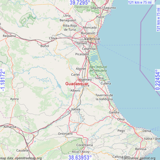
Guadassuar GPS coordinates[2]
39° 11' 11.868" North, 0° 28' 42.924" West
| Map corner | latitude | longitude |
|---|---|---|
| Upper-left | 39.7295°, | -1.18172° |
| Center: | 39.18663°, | -0.47859° |
| Lower-right: | 38.63953°, | 0.22454° |
| Map W x H: | 121.2×121.2 km | = 75.3×75.3mi |
| max Lat: | 43.74134° ⇑79.5% North |
| Guadassuar: | 39.18663° |
| min Lat: | ⇓20.5% South 27.64134° |
| min Long | Guadassuar | max Long |
| -18.00367° | -0.47859° | 4.2899° |
| W 82%⇐ | ⇒18% E |
Elevation
Elevation of Guadassuar is 34 m = 112 ft, and this is 564 m = 1850 ft below average elevation for this country.
| Max E: |
1682 m = 5518 ft | 93.6% |
| Avg. | 598 m = 1962 ft | |
| Guadassuar | 34 m = 112 ft | |
Min E: |
0 m = 0 ft | 6.4% |
See also: Spain elevation on elevation.city.
Geographical zone
Guadassuar is located in North temperate zone (between Tropic of Cancer and the Arctic Circle). Distance of this Northern Tropic circle is 1751.2 km =1088.1 mi to South.| Distance of | km | miles | from Guadassuar |
|---|---|---|---|
| North Pole | 5649.9 | 3510.7 | to North |
| Arctic Circle | 3044 | 1891.5 | to North |
| Tropic Cancer | 1751.2 | 1088.1 | to South |
| Equator | 4357.1 | 2707.4 | to South |


Nearby cities:
15 places around Guadassuar: (largest is in red/bold)
• Albalat de la Ribera
8.3 km =5.2 mi,  79°
79°
• Alberic
8.4 km =5.2 mi,  202°
202°
• Algemesí
3.7 km =2.3 mi, 83°
• Alginet
9 km =5.6 mi,  6°
6°
• Alzira
5.6 km =3.5 mi,  136°
136°
• Benicull de Xúquer
8.2 km =5.1 mi,  92°
92°
• Benimodo
5.2 km =3.2 mi,  306°
306°
• Benimuslem
6.2 km =3.9 mi,  191°
191°
• Carcaixent
7.7 km =4.8 mi,  159°
159°
• Carlet
5.8 km =3.6 mi,  320°
320°
• L'Alcúdia
2.6 km =1.6 mi,  296°
296°
• La Pobla Llarga
11.5 km =7.1 mi,  174°
174°
• Masalavés
6.1 km =3.8 mi,  218°
218°
• Polinyà de Xúquer
9.8 km =6.1 mi, 81°
• Tous
10.8 km =6.7 mi,  240°
240°
Sources, notices
• [Note1] Compared only with cities in Spain existing in our database
• [Src1] Map data: © OpenStreetMap contributors (CC-BY-SA)
• [Src2] Other city data from geonames.org with taken over terms of usage.
• [Src3] Geographical zone / Annual Mean Temperature by Robert A. Rohde @ Wikipedia
