Benicull de Xúquer geodata
Benicull de Xúquer (Valencia) is a populated place; located in Spain in Europe/Madrid (GMT+2) time zone. With population of 784 people, there are 3246 cities with bigger population in this country. Compared to other cities in Spain, 79.6% of cities are located further ↑North; 83.3% of cities are located further ←West and 97.6% of cities have higher elevation than Benicull de Xúquer. Note1


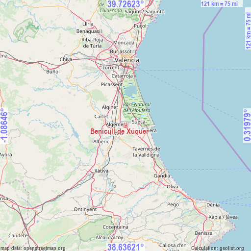
Benicull de Xúquer GPS coordinates[2]
39° 10' 59.988" North, 0° 22' 59.988" West
| Map corner | latitude | longitude |
|---|---|---|
| Upper-left | 39.72623°, | -1.08646° |
| Center: | 39.18333°, | -0.38333° |
| Lower-right: | 38.63621°, | 0.31979° |
| Map W x H: | 121.2×121.2 km | = 75.3×75.3mi |
| max Lat: | 43.74134° ⇑79.6% North |
| Benicull de Xúquer: | 39.18333° |
| min Lat: | ⇓20.4% South 27.64134° |
| min Long | Benicull de Xú | max Long |
| -18.00367° | -0.38333° | 4.2899° |
| W 83.3%⇐ | ⇒16.7% E |
Elevation
Elevation of Benicull de Xúquer is 13 m = 43 ft, and this is 585 m = 1919 ft below average elevation for this country.
| Max E: |
1682 m = 5518 ft | 97.6% |
| Avg. | 598 m = 1962 ft | |
| Benicull de Xúquer | 13 m = 43 ft | |
Min E: |
0 m = 0 ft | 2.4% |
See also: Spain elevation on elevation.city.
Geographical zone
Benicull de Xúquer is located in North temperate zone (between Tropic of Cancer and the Arctic Circle). Distance of this Northern Tropic circle is 1750.9 km =1088 mi to South.| Distance of | km | miles | from Benicull de Xúquer |
|---|---|---|---|
| North Pole | 5650.3 | 3510.9 | to North |
| Arctic Circle | 3044.4 | 1891.7 | to North |
| Tropic Cancer | 1750.9 | 1088 | to South |
| Equator | 4356.8 | 2707.2 | to South |


Nearby cities:
15 places around Benicull de Xúquer: (largest is in red/bold)
• Albalat de la Ribera
1.9 km =1.2 mi,  0°
0°
• Algemesí
4.6 km =2.9 mi,  279°
279°
• Alzira
5.7 km =3.5 mi,  229°
229°
• Benimuslem
11.1 km =6.9 mi,  238°
238°
• Carcaixent
8.8 km =5.5 mi,  219°
219°
• Corbera
4.7 km =2.9 mi,  142°
142°
• Favara
11.4 km =7.1 mi,  130°
130°
• Fortaleny
7.2 km =4.5 mi,  90°
90°
• Guadassuar
8.2 km =5.1 mi,  272°
272°
• L'Alcúdia
10.6 km =6.6 mi, 278°
• Llaurí
6.2 km =3.9 mi, 131°
• Polinyà de Xúquer
2.3 km =1.4 mi,  37°
37°
• Riola
4.7 km =2.9 mi,  66°
66°
• Sollana
10.6 km =6.6 mi, 0°
• Sueca
6.6 km =4.1 mi, 70°
Sources, notices
• [Note1] Compared only with cities in Spain existing in our database
• [Src1] Map data: © OpenStreetMap contributors (CC-BY-SA)
• [Src2] Other city data from geonames.org with taken over terms of usage.
• [Src3] Geographical zone / Annual Mean Temperature by Robert A. Rohde @ Wikipedia
