Gerena geodata
Gerena (Andalusia) is a seat of a third-order administrative division; located in Spain in Europe/Madrid (GMT+2) time zone. With population of 5,803 people, there are 1164 cities with bigger population in this country. Compared to other cities in Spain, 91.2% of cities are located further ↑North; 88% of cities are located further →East and 88.5% of cities have higher elevation than Gerena. Note1


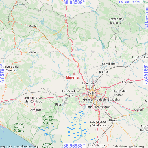
Gerena GPS coordinates[2]
37° 31' 46.452" North, 6° 9' 17.244" West
| Map corner | latitude | longitude |
|---|---|---|
| Upper-left | 38.08509°, | -6.85791° |
| Center: | 37.52957°, | -6.15479° |
| Lower-right: | 36.96988°, | -5.45166° |
| Map W x H: | 124×124 km | = 77.1×77.1mi |
| max Lat: | 43.74134° ⇑91.2% North |
| Gerena: | 37.52957° |
| min Lat: | ⇓8.8% South 27.64134° |
| min Long | Gerena | max Long |
| -18.00367° | -6.15479° | 4.2899° |
| W 12%⇐ | ⇒88% E |
Elevation
Elevation of Gerena is 87 m = 285 ft, and this is 511 m = 1677 ft below average elevation for this country.
| Max E: |
1682 m = 5518 ft | 88.5% |
| Avg. | 598 m = 1962 ft | |
| Gerena | 87 m = 285 ft | |
Min E: |
0 m = 0 ft | 11.5% |
See also: Spain elevation on elevation.city.
Geographical zone
Gerena is located in North temperate zone (between Tropic of Cancer and the Arctic Circle). Distance of this Northern Tropic circle is 1567 km =973.7 mi to South.| Distance of | km | miles | from Gerena |
|---|---|---|---|
| North Pole | 5834.2 | 3625.2 | to North |
| Arctic Circle | 3228.3 | 2006 | to North |
| Tropic Cancer | 1567 | 973.7 | to South |
| Equator | 4172.9 | 2592.9 | to South |


Nearby cities:
15 places around Gerena: (largest is in red/bold)
• Albaida del Aljarafe
11.8 km =7.3 mi,  185°
185°
• Alcalá del Río
15.3 km =9.5 mi,  94°
94°
• Aznalcóllar
10.2 km =6.3 mi,  263°
263°
• Castilleja de Guzmán
16 km =9.9 mi,  146°
146°
• El Garrobo
10.8 km =6.7 mi,  351°
351°
• Espartinas
16.7 km =10.4 mi,  171°
171°
• Guillena
8.8 km =5.5 mi,  80°
80°
• La Algaba
14.7 km =9.1 mi,  120°
120°
• La Rinconada
16.1 km =10 mi,  107°
107°
• Olivares
12.4 km =7.7 mi,  180°
180°
• Salteras
12.7 km =7.9 mi,  162°
162°
• Sanlúcar la Mayor
16.4 km =10.2 mi,  195°
195°
• Santiponce
14.5 km =9 mi,  136°
136°
• Valencina de la Concepción
14.5 km =9 mi, 150°
• Villanueva del Ariscal
14.9 km =9.3 mi, 175°
Sources, notices
• [Note1] Compared only with cities in Spain existing in our database
• [Src1] Map data: © OpenStreetMap contributors (CC-BY-SA)
• [Src2] Other city data from geonames.org with taken over terms of usage.
• [Src3] Geographical zone / Annual Mean Temperature by Robert A. Rohde @ Wikipedia
