Guillena geodata
Guillena (Andalusia) is a seat of a third-order administrative division; located in Spain in Europe/Madrid (GMT+2) time zone. With population of 11,109 people, there are 796 cities with bigger population in this country. Compared to other cities in Spain, 91.1% of cities are located further ↑North; 86.8% of cities are located further →East and 94.9% of cities have higher elevation than Guillena. Note1


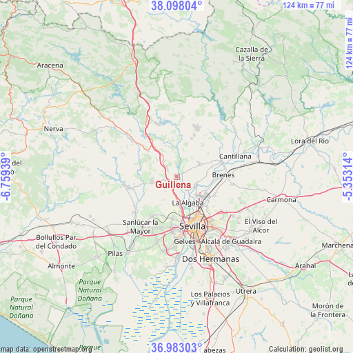
Guillena GPS coordinates[2]
37° 32' 33.432" North, 6° 3' 22.536" West
| Map corner | latitude | longitude |
|---|---|---|
| Upper-left | 38.09804°, | -6.75939° |
| Center: | 37.54262°, | -6.05626° |
| Lower-right: | 36.98303°, | -5.35314° |
| Map W x H: | 124×124 km | = 77.1×77.1mi |
| max Lat: | 43.74134° ⇑91.1% North |
| Guillena: | 37.54262° |
| min Lat: | ⇓8.9% South 27.64134° |
| min Long | Guillena | max Long |
| -18.00367° | -6.05626° | 4.2899° |
| W 13.2%⇐ | ⇒86.8% E |
Elevation
Elevation of Guillena is 25 m = 82 ft, and this is 573 m = 1880 ft below average elevation for this country.
| Max E: |
1682 m = 5518 ft | 94.9% |
| Avg. | 598 m = 1962 ft | |
| Guillena | 25 m = 82 ft | |
Min E: |
0 m = 0 ft | 5.1% |
See also: Spain elevation on elevation.city.
Geographical zone
Guillena is located in North temperate zone (between Tropic of Cancer and the Arctic Circle). Distance of this Northern Tropic circle is 1568.4 km =974.6 mi to South.| Distance of | km | miles | from Guillena |
|---|---|---|---|
| North Pole | 5832.7 | 3624.3 | to North |
| Arctic Circle | 3226.8 | 2005 | to North |
| Tropic Cancer | 1568.4 | 974.6 | to South |
| Equator | 4174.3 | 2593.8 | to South |


Nearby cities:
15 places around Guillena: (largest is in red/bold)
• Albaida del Aljarafe
16.4 km =10.2 mi,  216°
216°
• Alcalá del Río
7.1 km =4.4 mi,  112°
112°
• Brenes
16.3 km =10.1 mi,  87°
87°
• Burguillos
9.2 km =5.7 mi,  59°
59°
• Camas
15.8 km =9.8 mi,  172°
172°
• Castilblanco de los Arroyos
15.9 km =9.9 mi,  21°
21°
• Castilleja de Guzmán
14.8 km =9.2 mi,  179°
179°
• El Garrobo
13.8 km =8.6 mi,  312°
312°
• Gerena
8.8 km =5.5 mi,  260°
260°
• La Algaba
9.7 km =6 mi,  155°
155°
• La Rinconada
9.1 km =5.7 mi,  133°
133°
• Olivares
16.4 km =10.2 mi,  212°
212°
• Salteras
14.4 km =8.9 mi,  199°
199°
• Santiponce
12 km =7.5 mi, 173°
• Valencina de la Concepción
14.1 km =8.8 mi,  186°
186°
Sources, notices
• [Note1] Compared only with cities in Spain existing in our database
• [Src1] Map data: © OpenStreetMap contributors (CC-BY-SA)
• [Src2] Other city data from geonames.org with taken over terms of usage.
• [Src3] Geographical zone / Annual Mean Temperature by Robert A. Rohde @ Wikipedia
