La Algaba geodata
La Algaba (Andalusia) is a populated place; located in Spain in Europe/Madrid (GMT+2) time zone. With population of 14,942 people, there are 623 cities with bigger population in this country. Compared to other cities in Spain, 91.5% of cities are located further ↑North; 86.1% of cities are located further →East and 98.2% of cities have higher elevation than La Algaba. Note1


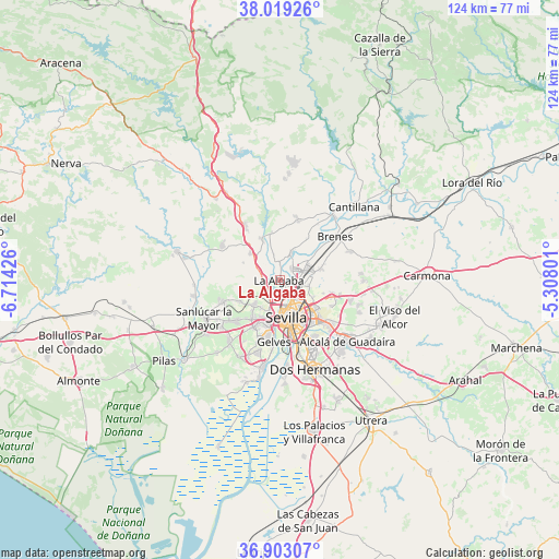
La Algaba GPS coordinates[2]
37° 27' 47.7" North, 6° 0' 40.068" West
| Map corner | latitude | longitude |
|---|---|---|
| Upper-left | 38.01926°, | -6.71426° |
| Center: | 37.46325°, | -6.01113° |
| Lower-right: | 36.90307°, | -5.30801° |
| Map W x H: | 124.1×124.1 km | = 77.1×77.1mi |
| max Lat: | 43.74134° ⇑91.5% North |
| La Algaba: | 37.46325° |
| min Lat: | ⇓8.5% South 27.64134° |
| min Long | La Algaba | max Long |
| -18.00367° | -6.01113° | 4.2899° |
| W 13.9%⇐ | ⇒86.1% E |
Elevation
Elevation of La Algaba is 11 m = 36 ft, and this is 587 m = 1926 ft below average elevation for this country.
| Max E: |
1682 m = 5518 ft | 98.2% |
| Avg. | 598 m = 1962 ft | |
| La Algaba | 11 m = 36 ft | |
Min E: |
0 m = 0 ft | 1.8% |
See also: Spain elevation on elevation.city.
Geographical zone
La Algaba is located in North temperate zone (between Tropic of Cancer and the Arctic Circle). Distance of this Northern Tropic circle is 1559.6 km =969.1 mi to South.| Distance of | km | miles | from La Algaba |
|---|---|---|---|
| North Pole | 5841.5 | 3629.7 | to North |
| Arctic Circle | 3235.7 | 2010.6 | to North |
| Tropic Cancer | 1559.6 | 969.1 | to South |
| Equator | 4165.5 | 2588.3 | to South |


Nearby cities:
15 places around La Algaba: (largest is in red/bold)
• Alcalá del Río
6.6 km =4.1 mi,  23°
23°
• Bormujos
11.3 km =7 mi,  208°
208°
• Camas
7.1 km =4.4 mi,  195°
195°
• Castilleja de Guzmán
7.1 km =4.4 mi, 213°
• Castilleja de la Cuesta
9.3 km =5.8 mi, 203°
• Gines
10.3 km =6.4 mi, 214°
• Guillena
9.7 km =6 mi,  335°
335°
• La Rinconada
3.7 km =2.3 mi,  46°
46°
• Salteras
10 km =6.2 mi,  241°
241°
• San Juan de Aznalfarache
11.9 km =7.4 mi,  191°
191°
• Santiponce
4.1 km =2.5 mi,  220°
220°
• Sevilla
9.5 km =5.9 mi,  159°
159°
• Tomares
10.5 km =6.5 mi, 196°
• Valdezorras
8.4 km =5.2 mi,  116°
116°
• Valencina de la Concepción
7.6 km =4.7 mi,  226°
226°
Sources, notices
• [Note1] Compared only with cities in Spain existing in our database
• [Src1] Map data: © OpenStreetMap contributors (CC-BY-SA)
• [Src2] Other city data from geonames.org with taken over terms of usage.
• [Src3] Geographical zone / Annual Mean Temperature by Robert A. Rohde @ Wikipedia
