Fuencaliente geodata
Fuencaliente (Castille-La Mancha) is a seat of a third-order administrative division; located in Spain in Europe/Madrid (GMT+2) time zone. In our database, there are 6762 cities with bigger population. Compared to other cities in Spain, 86.1% of cities are located further ↑North; 63.9% of cities are located further →East and 53.1% of cities have lower elevation than Fuencaliente. Note1
Administrative division(s):
- Level 1: Castille-La Mancha
- Level 2: Provincia de Ciudad Real
- Level 3: Fuencaliente


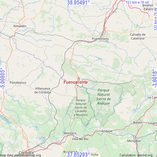
Fuencaliente GPS coordinates[2]
38° 24' 21.672" North, 4° 18' 17.712" West
| Map corner | latitude | longitude |
|---|---|---|
| Upper-left | 38.95491°, | -5.00805° |
| Center: | 38.40602°, | -4.30492° |
| Lower-right: | 37.85293°, | -3.6018° |
| Map W x H: | 122.5×122.5 km | = 76.1×76.1mi |
| max Lat: | 43.74134° ⇑86.1% North |
| Fuencaliente: | 38.40602° |
| min Lat: | ⇓13.9% South 27.64134° |
| min Long | Fuencaliente | max Long |
| -18.00367° | -4.30492° | 4.2899° |
| W 36.1%⇐ | ⇒63.9% E |
Elevation
Elevation of Fuencaliente is 692 m = 2270 ft, and this is 94 m = 308 ft above average elevation for this country.
| Max E: |
1682 m = 5518 ft | 46.9% |
| Fuencaliente | 692 m 2270 ft | |
| Avg. | 598 m = 1962 ft | |
Min E: |
0 m = 0 ft | 53.1% |
See also: Spain elevation on elevation.city.
Geographical zone
Fuencaliente is located in North temperate zone (between Tropic of Cancer and the Arctic Circle). Distance of this Northern Tropic circle is 1664.4 km =1034.2 mi to South.| Distance of | km | miles | from Fuencaliente |
|---|---|---|---|
| North Pole | 5736.7 | 3564.6 | to North |
| Arctic Circle | 3130.8 | 1945.4 | to North |
| Tropic Cancer | 1664.4 | 1034.2 | to South |
| Equator | 4270.3 | 2653.4 | to South |


Nearby cities:
15 places around Fuencaliente: (largest is in red/bold)
• Almodóvar del Campo
35.5 km =22.1 mi,  17°
17°
• Argamasilla de Calatrava
41.1 km =25.5 mi,  28°
28°
• Brazatortas
28.1 km =17.5 mi,  1°
1°
• Cabezarrubias del Puerto
25.5 km =15.8 mi, 24°
• Cardeña
15.2 km =9.4 mi,  186°
186°
• Conquista
17 km =10.6 mi,  267°
267°
• Hinojosas de Calatrava
27.3 km =17 mi, 31°
• Marmolejo
41.8 km =26 mi,  163°
163°
• Mestanza
27.8 km =17.3 mi,  47°
47°
• Pedroche
40 km =24.9 mi, 273°
• Puertollano
35.7 km =22.2 mi, 28°
• San Lorenzo de Calatrava
42.4 km =26.3 mi,  79°
79°
• Torrecampo
32.2 km =20 mi,  282°
282°
• Villanueva de Córdoba
29.7 km =18.5 mi,  251°
251°
• Villanueva de San Carlos
42 km =26.1 mi,  55°
55°
Sources, notices
• [Note1] Compared only with cities in Spain existing in our database
• [Src1] Map data: © OpenStreetMap contributors (CC-BY-SA)
• [Src2] Other city data from geonames.org with taken over terms of usage.
• [Src3] Geographical zone / Annual Mean Temperature by Robert A. Rohde @ Wikipedia
