Torrecampo geodata
Torrecampo (Andalusia) is a seat of a third-order administrative division; located in Spain in Europe/Madrid (GMT+2) time zone. With population of 1,384 people, there are 2560 cities with bigger population in this country. Compared to other cities in Spain, 85.8% of cities are located further ↑North; 68.3% of cities are located further →East and 54.6% of cities have higher elevation than Torrecampo. Note1


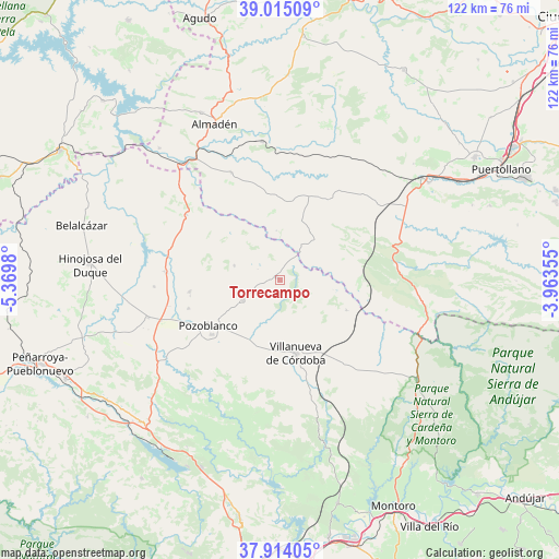
Torrecampo GPS coordinates[2]
38° 28' 0.012" North, 4° 40' 0.012" West
| Map corner | latitude | longitude |
|---|---|---|
| Upper-left | 39.01509°, | -5.3698° |
| Center: | 38.46667°, | -4.66667° |
| Lower-right: | 37.91405°, | -3.96355° |
| Map W x H: | 122.4×122.4 km | = 76.1×76.1mi |
| max Lat: | 43.74134° ⇑85.8% North |
| Torrecampo: | 38.46667° |
| min Lat: | ⇓14.2% South 27.64134° |
| min Long | Torrecampo | max Long |
| -18.00367° | -4.66667° | 4.2899° |
| W 31.7%⇐ | ⇒68.3% E |
Elevation
Elevation of Torrecampo is 601 m = 1972 ft, and this is 3 m = 10 ft above average elevation for this country.
| Max E: |
1682 m = 5518 ft | 54.6% |
| Torrecampo | 601 m 1972 ft | |
| Avg. | 598 m = 1962 ft | |
Min E: |
0 m = 0 ft | 45.4% |
See also: Spain elevation on elevation.city.
Geographical zone
Torrecampo is located in North temperate zone (between Tropic of Cancer and the Arctic Circle). Distance of this Northern Tropic circle is 1671.2 km =1038.4 mi to South.| Distance of | km | miles | from Torrecampo |
|---|---|---|---|
| North Pole | 5730 | 3560.5 | to North |
| Arctic Circle | 3124.1 | 1941.2 | to North |
| Tropic Cancer | 1671.2 | 1038.4 | to South |
| Equator | 4277.1 | 2657.7 | to South |


Nearby cities:
15 places around Torrecampo: (largest is in red/bold)
• Alamillo
25.9 km =16.1 mi,  335°
335°
• Alcaracejos
27.7 km =17.2 mi,  250°
250°
• Añora
21.1 km =13.1 mi, 254°
• Cardeña
37 km =23 mi,  126°
126°
• Conquista
16.3 km =10.1 mi,  117°
117°
• Dos Torres
20.4 km =12.7 mi,  264°
264°
• El Viso
24.7 km =15.3 mi,  274°
274°
• Fuencaliente
32.2 km =20 mi,  102°
102°
• Fuente la Lancha
32.4 km =20.1 mi, 260°
• Pedroche
9.4 km =5.8 mi,  243°
243°
• Pozoblanco
18.6 km =11.6 mi, 238°
• Santa Eufemia
25.1 km =15.6 mi,  306°
306°
• Villanueva de Córdoba
16.3 km =10.1 mi,  168°
168°
• Villanueva del Duque
30.5 km =19 mi, 252°
• Villaralto
27.6 km =17.1 mi, 266°
Sources, notices
• [Note1] Compared only with cities in Spain existing in our database
• [Src1] Map data: © OpenStreetMap contributors (CC-BY-SA)
• [Src2] Other city data from geonames.org with taken over terms of usage.
• [Src3] Geographical zone / Annual Mean Temperature by Robert A. Rohde @ Wikipedia
