Villanueva de Córdoba geodata
Villanueva de Córdoba (Andalusia) is a seat of a third-order administrative division; located in Spain in Europe/Madrid (GMT+1) time zone. With population of 10,057 people, there are 857 cities with bigger population in this country. Compared to other cities in Spain, 86.6% of cities are located further ↑North; 67.6% of cities are located further →East and 57.9% of cities have lower elevation than Villanueva de Córdoba. Note1
Administrative division(s):
- Level 1: Andalusia
- Level 2: Province of Córdoba
- Level 3: Villanueva de Córdoba


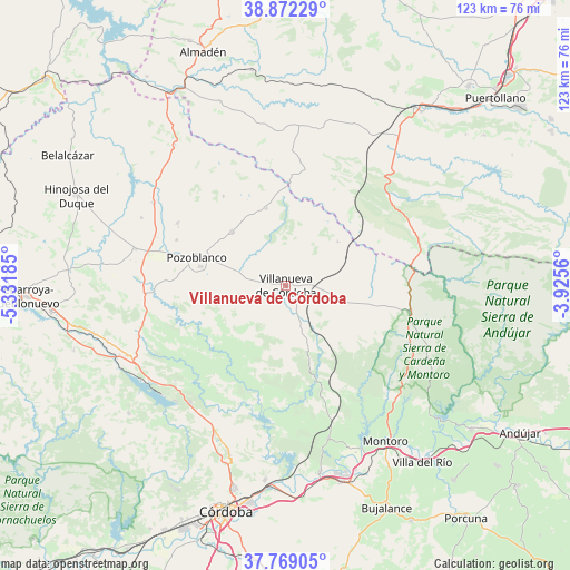
Villanueva de Córdoba GPS coordinates[2]
38° 19' 21.972" North, 4° 37' 43.428" West
| Map corner | latitude | longitude |
|---|---|---|
| Upper-left | 38.87229°, | -5.33185° |
| Center: | 38.32277°, | -4.62873° |
| Lower-right: | 37.76905°, | -3.9256° |
| Map W x H: | 122.7×122.7 km | = 76.2×76.2mi |
| max Lat: | 43.74134° ⇑86.6% North |
| Villanueva de Córdoba: | 38.32277° |
| min Lat: | ⇓13.4% South 27.64134° |
| min Long | Villanueva de C | max Long |
| -18.00367° | -4.62873° | 4.2899° |
| W 32.4%⇐ | ⇒67.6% E |
Elevation
Elevation of Villanueva de Córdoba is 729 m = 2392 ft, and this is 131 m = 430 ft above average elevation for this country.
| Max E: |
1682 m = 5518 ft | 42.1% |
| Villanueva de Córdoba | 729 m 2392 ft | |
| Avg. | 598 m = 1962 ft | |
Min E: |
0 m = 0 ft | 57.9% |
See also: Spain elevation on elevation.city.
Geographical zone
Villanueva de Córdoba is located in North temperate zone (between Tropic of Cancer and the Arctic Circle). Distance of this Northern Tropic circle is 1655.2 km =1028.5 mi to South.| Distance of | km | miles | from Villanueva de Córdoba |
|---|---|---|---|
| North Pole | 5746 | 3570.4 | to North |
| Arctic Circle | 3140.1 | 1951.2 | to North |
| Tropic Cancer | 1655.2 | 1028.5 | to South |
| Equator | 4261.1 | 2647.7 | to South |


Nearby cities:
15 places around Villanueva de Córdoba: (largest is in red/bold)
• Adamuz
34.2 km =21.3 mi,  164°
164°
• Alcaracejos
30.2 km =18.8 mi,  282°
282°
• Añora
25.9 km =16.1 mi,  293°
293°
• Cardeña
27.3 km =17 mi,  102°
102°
• Conquista
14.1 km =8.8 mi,  52°
52°
• Dos Torres
27.6 km =17.1 mi,  300°
300°
• El Viso
33.2 km =20.6 mi, 302°
• Fuencaliente
29.7 km =18.5 mi,  71°
71°
• Obejo
25.9 km =16.1 mi,  215°
215°
• Pedroche
16.6 km =10.3 mi,  315°
315°
• Pozoblanco
20.1 km =12.5 mi, 288°
• Torrecampo
16.3 km =10.1 mi,  348°
348°
• Villaharta
31.7 km =19.7 mi,  228°
228°
• Villanueva del Duque
33.1 km =20.6 mi, 281°
• Villaralto
34 km =21.1 mi, 294°
Sources, notices
• [Note1] Compared only with cities in Spain existing in our database
• [Src1] Map data: © OpenStreetMap contributors (CC-BY-SA)
• [Src2] Other city data from geonames.org with taken over terms of usage.
• [Src3] Geographical zone / Annual Mean Temperature by Robert A. Rohde @ Wikipedia
