Fasnia geodata
Fasnia (Canary Islands) is a seat of a third-order administrative division; located in Spain in Atlantic/Canary (GMT+1) time zone. With population of 2,777 people, there are 1788 cities with bigger population in this country. Compared to other cities in Spain, 99.3% of cities are located further ↑North; 99.3% of cities are located further →East and 67.2% of cities have higher elevation than Fasnia. Note1
Administrative division(s):
- Level 1: Canary Islands
- Level 2: Provincia de Santa Cruz de Tenerife
- Level 3: Fasnia


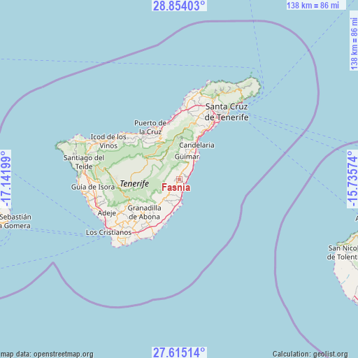
Fasnia GPS coordinates[2]
28° 14' 10.968" North, 16° 26' 19.896" West
| Map corner | latitude | longitude |
|---|---|---|
| Upper-left | 28.85403°, | -17.14199° |
| Center: | 28.23638°, | -16.43886° |
| Lower-right: | 27.61514°, | -15.73574° |
| Map W x H: | 137.8×137.8 km | = 85.6×85.6mi |
| max Lat: | 43.74134° ⇑99.3% North |
| Fasnia: | 28.23638° |
| min Lat: | ⇓0.7% South 27.64134° |
| min Long | Fasnia | max Long |
| -18.00367° | -16.43886° | 4.2899° |
| W 0.7%⇐ | ⇒99.3% E |
Elevation
Elevation of Fasnia is 429 m = 1407 ft, and this is 169 m = 554 ft below average elevation for this country.
| Max E: |
1682 m = 5518 ft | 67.2% |
| Avg. | 598 m = 1962 ft | |
| Fasnia | 429 m = 1407 ft | |
Min E: |
0 m = 0 ft | 32.8% |
See also: Spain elevation on elevation.city.
Geographical zone
Fasnia is located in North temperate zone (between Tropic of Cancer and the Arctic Circle). Distance of this Northern Tropic circle is 533.7 km =331.6 mi to South.| Distance of | km | miles | from Fasnia |
|---|---|---|---|
| North Pole | 6867.5 | 4267.3 | to North |
| Arctic Circle | 4261.6 | 2648 | to North |
| Tropic Cancer | 533.7 | 331.6 | to South |
| Equator | 3139.6 | 1950.9 | to South |


Nearby cities:
15 places around Fasnia: (largest is in red/bold)
• Arafo
11.6 km =7.2 mi,  7°
7°
• Candelaria
14.7 km =9.1 mi,  26°
26°
• El Médano
23.2 km =14.4 mi,  204°
204°
• Granadilla de Abona
18.7 km =11.6 mi,  225°
225°
• Güimar
8.7 km =5.4 mi,  17°
17°
• La Orotava
19 km =11.8 mi,  334°
334°
• La Victoria de Acentejo
21.9 km =13.6 mi,  353°
353°
• Lomo de Arico
8.9 km =5.5 mi,  209°
209°
• Los Realejos
21.7 km =13.5 mi,  319°
319°
• Puerto de la Cruz
22.5 km =14 mi, 331°
• Realejo Alto
21.2 km =13.2 mi, 317°
• San Isidro
21.3 km =13.2 mi, 213°
• San Miguel De Abona
23.3 km =14.5 mi, 228°
• Santa Úrsula
21.7 km =13.5 mi, 346°
• Vilaflor
21.3 km =13.2 mi,  245°
245°
Sources, notices
• [Note1] Compared only with cities in Spain existing in our database
• [Src1] Map data: © OpenStreetMap contributors (CC-BY-SA)
• [Src2] Other city data from geonames.org with taken over terms of usage.
• [Src3] Geographical zone / Annual Mean Temperature by Robert A. Rohde @ Wikipedia
