Güimar geodata
Güimar (Canary Islands) is a populated place; located in Spain in Atlantic/Canary (GMT+1) time zone. With population of 17,662 people, there are 537 cities with bigger population in this country. Compared to other cities in Spain, 99.3% of cities are located further ↑North; 99.2% of cities are located further →East and 76.5% of cities have higher elevation than Güimar. Note1
Administrative division(s):
- Level 1: Canary Islands
- Level 2: Provincia de Santa Cruz de Tenerife
- Level 3: Güímar


Güimar GPS coordinates[2]
28° 18' 40.392" North, 16° 24' 45.936" West
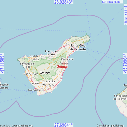
| Map corner | latitude | longitude |
|---|---|---|
| Upper-left | 28.92843°, | -17.11589° |
| Center: | 28.31122°, | -16.41276° |
| Lower-right: | 27.69041°, | -15.70964° |
| Map W x H: | 137.7×137.7 km | = 85.6×85.6mi |
| max Lat: | 43.74134° ⇑99.3% North |
| Güimar: | 28.31122° |
| min Lat: | ⇓0.7% South 27.64134° |
| min Long | Güimar | max Long |
| -18.00367° | -16.41276° | 4.2899° |
| W 0.8%⇐ | ⇒99.2% E |
Elevation
Elevation of Güimar is 278 m = 912 ft, and this is 320 m = 1050 ft below average elevation for this country.
| Max E: |
1682 m = 5518 ft | 76.5% |
| Avg. | 598 m = 1962 ft | |
| Güimar | 278 m = 912 ft | |
Min E: |
0 m = 0 ft | 23.5% |
See also: Spain elevation on elevation.city.
Geographical zone
Güimar is located in North temperate zone (between Tropic of Cancer and the Arctic Circle). Distance of this Northern Tropic circle is 542 km =336.8 mi to South.| Distance of | km | miles | from Güimar |
|---|---|---|---|
| North Pole | 6859.1 | 4262 | to North |
| Arctic Circle | 4253.3 | 2642.9 | to North |
| Tropic Cancer | 542 | 336.8 | to South |
| Equator | 3147.9 | 1956 | to South |


Nearby cities:
15 places around Güimar: (largest is in red/bold)
• Arafo
3.3 km =2.1 mi,  343°
343°
• Candelaria
6.2 km =3.9 mi,  38°
38°
• Fasnia
8.7 km =5.4 mi,  197°
197°
• La Laguna
21.4 km =13.3 mi,  25°
25°
• La Matanza de Acentejo
16.1 km =10 mi,  347°
347°
• La Orotava
14 km =8.7 mi,  309°
309°
• La Victoria de Acentejo
14.3 km =8.9 mi, 340°
• Lomo de Arico
17.5 km =10.9 mi, 203°
• Los Realejos
18.5 km =11.5 mi,  296°
296°
• Puerto de la Cruz
17.5 km =10.9 mi, 310°
• Realejo Alto
18.4 km =11.4 mi,  293°
293°
• Santa Cruz de Tenerife
23.3 km =14.5 mi, 41°
• Santa Úrsula
14.8 km =9.2 mi,  329°
329°
• Sauzal
17.3 km =10.7 mi,  358°
358°
• Tacoronte
18.4 km =11.4 mi,  0°
0°
Sources, notices
• [Note1] Compared only with cities in Spain existing in our database
• [Src1] Map data: © OpenStreetMap contributors (CC-BY-SA)
• [Src2] Other city data from geonames.org with taken over terms of usage.
• [Src3] Geographical zone / Annual Mean Temperature by Robert A. Rohde @ Wikipedia
