Arafo geodata
Arafo (Canary Islands) is a seat of a third-order administrative division; located in Spain in Atlantic/Canary (GMT+1) time zone. With population of 5,375 people, there are 1238 cities with bigger population in this country. Compared to other cities in Spain, 99.2% of cities are located further ↑North; 99.2% of cities are located further →East and 61.9% of cities have higher elevation than Arafo. Note1
Administrative division(s):
- Level 1: Canary Islands
- Level 2: Provincia de Santa Cruz de Tenerife
- Level 3: Arafo


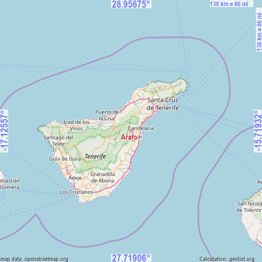
Arafo GPS coordinates[2]
28° 20' 22.956" North, 16° 25' 20.784" West
| Map corner | latitude | longitude |
|---|---|---|
| Upper-left | 28.95675°, | -17.12557° |
| Center: | 28.33971°, | -16.42244° |
| Lower-right: | 27.71906°, | -15.71932° |
| Map W x H: | 137.6×137.6 km | = 85.5×85.5mi |
| max Lat: | 43.74134° ⇑99.2% North |
| Arafo: | 28.33971° |
| min Lat: | ⇓0.8% South 27.64134° |
| min Long | Arafo | max Long |
| -18.00367° | -16.42244° | 4.2899° |
| W 0.8%⇐ | ⇒99.2% E |
Elevation
Elevation of Arafo is 500 m = 1640 ft, and this is 98 m = 322 ft below average elevation for this country.
| Max E: |
1682 m = 5518 ft | 61.9% |
| Avg. | 598 m = 1962 ft | |
| Arafo | 500 m = 1640 ft | |
Min E: |
0 m = 0 ft | 38.1% |
See also: Spain elevation on elevation.city.
Geographical zone
Arafo is located in North temperate zone (between Tropic of Cancer and the Arctic Circle). Distance of this Northern Tropic circle is 545.2 km =338.8 mi to South.| Distance of | km | miles | from Arafo |
|---|---|---|---|
| North Pole | 6856 | 4260.1 | to North |
| Arctic Circle | 4250.1 | 2640.9 | to North |
| Tropic Cancer | 545.2 | 338.8 | to South |
| Equator | 3151.1 | 1958 | to South |


Nearby cities:
15 places around Arafo: (largest is in red/bold)
• Candelaria
5.2 km =3.2 mi,  70°
70°
• Fasnia
11.6 km =7.2 mi,  187°
187°
• Güimar
3.3 km =2.1 mi,  163°
163°
• La Laguna
19 km =11.8 mi,  31°
31°
• La Matanza de Acentejo
12.8 km =8 mi,  349°
349°
• La Orotava
11.4 km =7.1 mi,  299°
299°
• La Victoria de Acentejo
11 km =6.8 mi,  339°
339°
• Lomo de Arico
20.1 km =12.5 mi,  197°
197°
• Los Realejos
16.5 km =10.3 mi,  287°
287°
• Puerto de la Cruz
14.9 km =9.3 mi, 303°
• Realejo Alto
16.5 km =10.3 mi,  284°
284°
• Santa Cruz de Tenerife
21.8 km =13.5 mi,  48°
48°
• Santa Úrsula
11.6 km =7.2 mi,  325°
325°
• Sauzal
14.1 km =8.8 mi,  2°
2°
• Tacoronte
15.3 km =9.5 mi, 4°
Sources, notices
• [Note1] Compared only with cities in Spain existing in our database
• [Src1] Map data: © OpenStreetMap contributors (CC-BY-SA)
• [Src2] Other city data from geonames.org with taken over terms of usage.
• [Src3] Geographical zone / Annual Mean Temperature by Robert A. Rohde @ Wikipedia
