Burguillos de Toledo geodata
Burguillos de Toledo (Castille-La Mancha) is a seat of a third-order administrative division; located in Spain in Europe/Madrid (GMT+2) time zone. With population of 1,708 people, there are 2331 cities with bigger population in this country. Compared to other cities in Spain, 73% of cities are located further ↑North; 59.6% of cities are located further →East and 52% of cities have lower elevation than Burguillos de Toledo. Note1
Administrative division(s):
- Level 1: Castille-La Mancha
- Level 2: Province of Toledo
- Level 3: Burguillos de Toledo


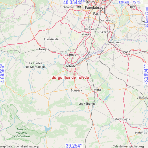
Burguillos de Toledo GPS coordinates[2]
39° 47' 46.86" North, 3° 59' 33.144" West
| Map corner | latitude | longitude |
|---|---|---|
| Upper-left | 40.33445°, | -4.69566° |
| Center: | 39.79635°, | -3.99254° |
| Lower-right: | 39.254°, | -3.28941° |
| Map W x H: | 120.1×120.1 km | = 74.6×74.6mi |
| max Lat: | 43.74134° ⇑73% North |
| Burguillos de Toledo: | 39.79635° |
| min Lat: | ⇓27% South 27.64134° |
| min Long | Burguillos de T | max Long |
| -18.00367° | -3.99254° | 4.2899° |
| W 40.4%⇐ | ⇒59.6% E |
Elevation
Elevation of Burguillos de Toledo is 680 m = 2231 ft, and this is 82 m = 269 ft above average elevation for this country.
| Max E: |
1682 m = 5518 ft | 48% |
| Burguillos de Toledo | 680 m 2231 ft | |
| Avg. | 598 m = 1962 ft | |
Min E: |
0 m = 0 ft | 52% |
See also: Spain elevation on elevation.city.
Geographical zone
Burguillos de Toledo is located in North temperate zone (between Tropic of Cancer and the Arctic Circle). Distance of this Northern Tropic circle is 1819 km =1130.3 mi to South.| Distance of | km | miles | from Burguillos de Toledo |
|---|---|---|---|
| North Pole | 5582.1 | 3468.6 | to North |
| Arctic Circle | 2976.2 | 1849.3 | to North |
| Tropic Cancer | 1819 | 1130.3 | to South |
| Equator | 4424.9 | 2749.5 | to South |


Nearby cities:
15 places around Burguillos de Toledo: (largest is in red/bold)
• Ajofrín
9.5 km =5.9 mi,  174°
174°
• Almonacid de Toledo
12.8 km =8 mi,  111°
111°
• Bargas
16.3 km =10.1 mi,  351°
351°
• Casasbuenas
12 km =7.5 mi,  251°
251°
• Chueca
8.3 km =5.2 mi,  149°
149°
• Cobisa
2.9 km =1.8 mi,  287°
287°
• Guadamur
13.5 km =8.4 mi,  277°
277°
• Layos
6.5 km =4 mi, 250°
• Mazarambroz
11.6 km =7.2 mi,  191°
191°
• Nambroca
4.1 km =2.5 mi,  87°
87°
• Olías del Rey
16.5 km =10.3 mi,  1°
1°
• Polán
15 km =9.3 mi,  266°
266°
• Sonseca
13.3 km =8.3 mi, 173°
• Toledo
7.3 km =4.5 mi,  339°
339°
• Villaminaya
14 km =8.7 mi,  131°
131°
Sources, notices
• [Note1] Compared only with cities in Spain existing in our database
• [Src1] Map data: © OpenStreetMap contributors (CC-BY-SA)
• [Src2] Other city data from geonames.org with taken over terms of usage.
• [Src3] Geographical zone / Annual Mean Temperature by Robert A. Rohde @ Wikipedia
