Chirivel geodata
Chirivel (Andalusia) is a seat of a third-order administrative division; located in Spain in Europe/Madrid (GMT+2) time zone. With population of 1,816 people, there are 2276 cities with bigger population in this country. Compared to other cities in Spain, 90.8% of cities are located further ↑North; 63.9% of cities are located further ←West and 90.8% of cities have lower elevation than Chirivel. Note1


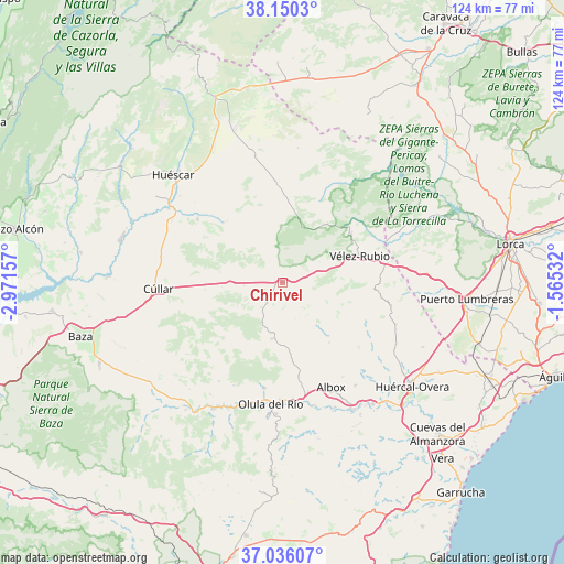
Chirivel GPS coordinates[2]
37° 35' 42.972" North, 2° 16' 6.384" West
| Map corner | latitude | longitude |
|---|---|---|
| Upper-left | 38.1503°, | -2.97157° |
| Center: | 37.59527°, | -2.26844° |
| Lower-right: | 37.03607°, | -1.56532° |
| Map W x H: | 123.9×123.9 km | = 77×77mi |
| max Lat: | 43.74134° ⇑90.8% North |
| Chirivel: | 37.59527° |
| min Lat: | ⇓9.2% South 27.64134° |
| min Long | Chirivel | max Long |
| -18.00367° | -2.26844° | 4.2899° |
| W 63.9%⇐ | ⇒36.1% E |
Elevation
Elevation of Chirivel is 1046 m = 3432 ft, and this is 448 m = 1470 ft above average elevation for this country.
| Max E: |
1682 m = 5518 ft | 9.2% |
| Chirivel | 1046 m 3432 ft | |
| Avg. | 598 m = 1962 ft | |
Min E: |
0 m = 0 ft | 90.8% |
See also: Spain elevation on elevation.city.
Geographical zone
Chirivel is located in North temperate zone (between Tropic of Cancer and the Arctic Circle). Distance of this Northern Tropic circle is 1574.3 km =978.2 mi to South.| Distance of | km | miles | from Chirivel |
|---|---|---|---|
| North Pole | 5826.9 | 3620.7 | to North |
| Arctic Circle | 3221 | 2001.4 | to North |
| Tropic Cancer | 1574.3 | 978.2 | to South |
| Equator | 4180.2 | 2597.5 | to South |


Nearby cities:
15 places around Chirivel: (largest is in red/bold)
• Albox
25.3 km =15.7 mi,  155°
155°
• Cantoria
27.9 km =17.3 mi,  166°
166°
• Fines
26.1 km =16.2 mi,  177°
177°
• Lúcar
25.7 km =16 mi,  212°
212°
• María
15.7 km =9.8 mi,  35°
35°
• Olula del Río
26.9 km =16.7 mi,  185°
185°
• Orce
23.1 km =14.4 mi,  307°
307°
• Oria
12.4 km =7.7 mi, 190°
• Partaloa
21.2 km =13.2 mi, 169°
• Purchena
28.7 km =17.8 mi,  196°
196°
• Somontín
25 km =15.5 mi, 205°
• Taberno
21.9 km =13.6 mi,  129°
129°
• Urrácal
23.6 km =14.7 mi, 201°
• Velez Rubio
17.9 km =11.1 mi,  70°
70°
• Vélez-Blanco
18.6 km =11.6 mi,  54°
54°
Sources, notices
• [Note1] Compared only with cities in Spain existing in our database
• [Src1] Map data: © OpenStreetMap contributors (CC-BY-SA)
• [Src2] Other city data from geonames.org with taken over terms of usage.
• [Src3] Geographical zone / Annual Mean Temperature by Robert A. Rohde @ Wikipedia
