Cantoria geodata
Cantoria (Andalusia) is a seat of a third-order administrative division; located in Spain in Europe/Madrid (GMT+2) time zone. With population of 3,502 people, there are 1586 cities with bigger population in this country. Compared to other cities in Spain, 92.5% of cities are located further ↑North; 64.9% of cities are located further ←West and 70% of cities have higher elevation than Cantoria. Note1


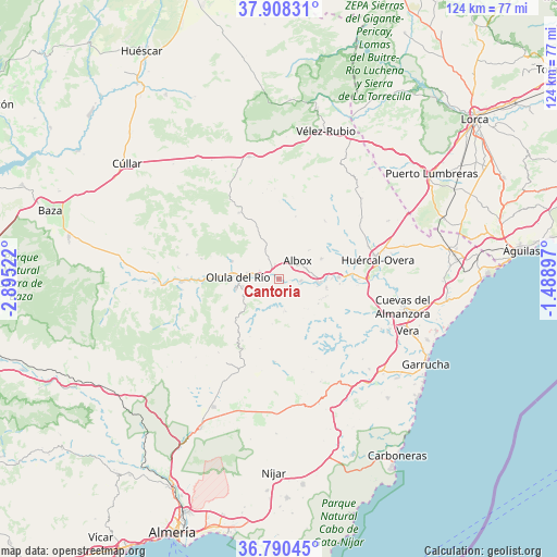
Cantoria GPS coordinates[2]
37° 21' 5.256" North, 2° 11' 31.524" West
| Map corner | latitude | longitude |
|---|---|---|
| Upper-left | 37.90831°, | -2.89522° |
| Center: | 37.35146°, | -2.19209° |
| Lower-right: | 36.79045°, | -1.48897° |
| Map W x H: | 124.3×124.3 km | = 77.2×77.2mi |
| max Lat: | 43.74134° ⇑92.5% North |
| Cantoria: | 37.35146° |
| min Lat: | ⇓7.5% South 27.64134° |
| min Long | Cantoria | max Long |
| -18.00367° | -2.19209° | 4.2899° |
| W 64.9%⇐ | ⇒35.1% E |
Elevation
Elevation of Cantoria is 380 m = 1247 ft, and this is 218 m = 715 ft below average elevation for this country.
| Max E: |
1682 m = 5518 ft | 70% |
| Avg. | 598 m = 1962 ft | |
| Cantoria | 380 m = 1247 ft | |
Min E: |
0 m = 0 ft | 30% |
See also: Spain elevation on elevation.city.
Geographical zone
Cantoria is located in North temperate zone (between Tropic of Cancer and the Arctic Circle). Distance of this Northern Tropic circle is 1547.2 km =961.4 mi to South.| Distance of | km | miles | from Cantoria |
|---|---|---|---|
| North Pole | 5854 | 3637.5 | to North |
| Arctic Circle | 3248.1 | 2018.3 | to North |
| Tropic Cancer | 1547.2 | 961.4 | to South |
| Equator | 4153.1 | 2580.6 | to South |


Nearby cities:
15 places around Cantoria: (largest is in red/bold)
• Albox
5.6 km =3.5 mi,  42°
42°
• Albánchez
7.6 km =4.7 mi,  173°
173°
• Alcudia de Monteagud
14.5 km =9 mi,  207°
207°
• Arboleas
10.5 km =6.5 mi,  90°
90°
• Benitagla
14 km =8.7 mi,  197°
197°
• Chercos
12.6 km =7.8 mi, 211°
• Cóbdar
10.1 km =6.3 mi,  189°
189°
• Fines
5.9 km =3.7 mi,  280°
280°
• Laroya
13.9 km =8.6 mi,  244°
244°
• Macael
9.8 km =6.1 mi,  258°
258°
• Olula del Río
9.3 km =5.8 mi,  272°
272°
• Partaloa
6.9 km =4.3 mi,  334°
334°
• Purchena
14.9 km =9.3 mi, 268°
• Tahal
16 km =9.9 mi, 210°
• Zurgena
13.5 km =8.4 mi, 94°
Sources, notices
• [Note1] Compared only with cities in Spain existing in our database
• [Src1] Map data: © OpenStreetMap contributors (CC-BY-SA)
• [Src2] Other city data from geonames.org with taken over terms of usage.
• [Src3] Geographical zone / Annual Mean Temperature by Robert A. Rohde @ Wikipedia
