Partaloa geodata
Partaloa (Andalusia) is a seat of a third-order administrative division; located in Spain in Europe/Madrid (GMT+2) time zone. With population of 584 people, there are 3652 cities with bigger population in this country. Compared to other cities in Spain, 91.9% of cities are located further ↑North; 64.4% of cities are located further ←West and 59% of cities have higher elevation than Partaloa. Note1


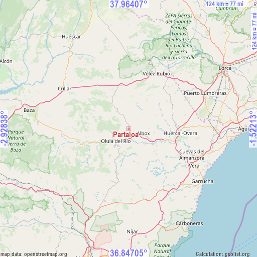
Partaloa GPS coordinates[2]
37° 24' 27.504" North, 2° 13' 30.936" West
| Map corner | latitude | longitude |
|---|---|---|
| Upper-left | 37.96407°, | -2.92838° |
| Center: | 37.40764°, | -2.22526° |
| Lower-right: | 36.84705°, | -1.52213° |
| Map W x H: | 124.2×124.2 km | = 77.2×77.2mi |
| max Lat: | 43.74134° ⇑91.9% North |
| Partaloa: | 37.40764° |
| min Lat: | ⇓8.1% South 27.64134° |
| min Long | Partaloa | max Long |
| -18.00367° | -2.22526° | 4.2899° |
| W 64.4%⇐ | ⇒35.6% E |
Elevation
Elevation of Partaloa is 540 m = 1772 ft, and this is 58 m = 190 ft below average elevation for this country.
| Max E: |
1682 m = 5518 ft | 59% |
| Avg. | 598 m = 1962 ft | |
| Partaloa | 540 m = 1772 ft | |
Min E: |
0 m = 0 ft | 41% |
See also: Spain elevation on elevation.city.
Geographical zone
Partaloa is located in North temperate zone (between Tropic of Cancer and the Arctic Circle). Distance of this Northern Tropic circle is 1553.4 km =965.2 mi to South.| Distance of | km | miles | from Partaloa |
|---|---|---|---|
| North Pole | 5847.7 | 3633.6 | to North |
| Arctic Circle | 3241.8 | 2014.4 | to North |
| Tropic Cancer | 1553.4 | 965.2 | to South |
| Equator | 4159.3 | 2584.5 | to South |


Nearby cities:
15 places around Partaloa: (largest is in red/bold)
• Albox
7 km =4.3 mi,  107°
107°
• Albánchez
14.3 km =8.9 mi,  164°
164°
• Arboleas
14.8 km =9.2 mi,  115°
115°
• Cantoria
6.9 km =4.3 mi,  154°
154°
• Cóbdar
16.3 km =10.1 mi,  175°
175°
• Fines
6 km =3.7 mi,  209°
209°
• Laroya
15.6 km =9.7 mi,  218°
218°
• Macael
10.6 km =6.6 mi, 218°
• Olula del Río
8.7 km =5.4 mi,  227°
227°
• Oria
10.5 km =6.5 mi,  325°
325°
• Purchena
13.7 km =8.5 mi,  240°
240°
• Somontín
14.5 km =9 mi,  263°
263°
• Suflí
16.3 km =10.1 mi, 241°
• Taberno
14.7 km =9.1 mi,  62°
62°
• Urrácal
12.4 km =7.7 mi, 264°
Sources, notices
• [Note1] Compared only with cities in Spain existing in our database
• [Src1] Map data: © OpenStreetMap contributors (CC-BY-SA)
• [Src2] Other city data from geonames.org with taken over terms of usage.
• [Src3] Geographical zone / Annual Mean Temperature by Robert A. Rohde @ Wikipedia
