Cheste geodata
Cheste (Valencia) is a seat of a third-order administrative division; located in Spain in Europe/Madrid (GMT+2) time zone. With population of 7,255 people, there are 1007 cities with bigger population in this country. Compared to other cities in Spain, 77.1% of cities are located further ↑North; 80% of cities are located further ←West and 80.6% of cities have higher elevation than Cheste. Note1


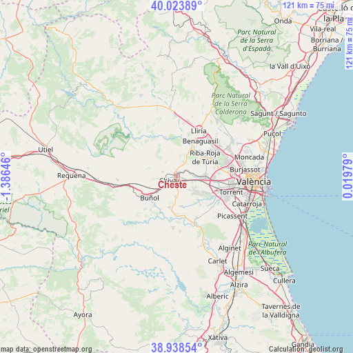
Cheste GPS coordinates[2]
39° 28' 59.988" North, 0° 40' 59.988" West
| Map corner | latitude | longitude |
|---|---|---|
| Upper-left | 40.02389°, | -1.38646° |
| Center: | 39.48333°, | -0.68333° |
| Lower-right: | 38.93854°, | 0.01979° |
| Map W x H: | 120.7×120.7 km | = 75×75mi |
| max Lat: | 43.74134° ⇑77.1% North |
| Cheste: | 39.48333° |
| min Lat: | ⇓22.9% South 27.64134° |
| min Long | Cheste | max Long |
| -18.00367° | -0.68333° | 4.2899° |
| W 80%⇐ | ⇒20% E |
Elevation
Elevation of Cheste is 209 m = 686 ft, and this is 389 m = 1276 ft below average elevation for this country.
| Max E: |
1682 m = 5518 ft | 80.6% |
| Avg. | 598 m = 1962 ft | |
| Cheste | 209 m = 686 ft | |
Min E: |
0 m = 0 ft | 19.4% |
See also: Spain elevation on elevation.city.
Geographical zone
Cheste is located in North temperate zone (between Tropic of Cancer and the Arctic Circle). Distance of this Northern Tropic circle is 1784.2 km =1108.7 mi to South.| Distance of | km | miles | from Cheste |
|---|---|---|---|
| North Pole | 5616.9 | 3490.2 | to North |
| Arctic Circle | 3011 | 1870.9 | to North |
| Tropic Cancer | 1784.2 | 1108.7 | to South |
| Equator | 4390.1 | 2727.9 | to South |


Nearby cities:
15 places around Cheste: (largest is in red/bold)
• Alborache
13.2 km =8.2 mi,  212°
212°
• Benaguasil
15.6 km =9.7 mi,  33°
33°
• Bugarra
16.5 km =10.3 mi,  334°
334°
• Buñol
11.3 km =7 mi,  229°
229°
• Chiva
3.4 km =2.1 mi,  237°
237°
• Godelleta
7.4 km =4.6 mi,  180°
180°
• L'Eliana
15.9 km =9.9 mi,  54°
54°
• La Pobla de Vallbona
16.8 km =10.4 mi,  40°
40°
• Macastre
14 km =8.7 mi,  217°
217°
• Monserrat
14.8 km =9.2 mi,  151°
151°
• Pedralba
13.3 km =8.3 mi,  347°
347°
• Ribarroja del Turia
11.9 km =7.4 mi, 54°
• Turís
11.2 km =7 mi,  187°
187°
• Vilamarxant
10.8 km =6.7 mi, 27°
• Yátova
15 km =9.3 mi, 222°
Sources, notices
• [Note1] Compared only with cities in Spain existing in our database
• [Src1] Map data: © OpenStreetMap contributors (CC-BY-SA)
• [Src2] Other city data from geonames.org with taken over terms of usage.
• [Src3] Geographical zone / Annual Mean Temperature by Robert A. Rohde @ Wikipedia
