L'Eliana geodata
L'Eliana (Valencia) is a populated place; located in Spain in Europe/Madrid (GMT+2) time zone. With population of 16,552 people, there are 567 cities with bigger population in this country. Compared to other cities in Spain, 76.2% of cities are located further ↑North; 81.3% of cities are located further ←West and 88.3% of cities have higher elevation than L'Eliana. Note1


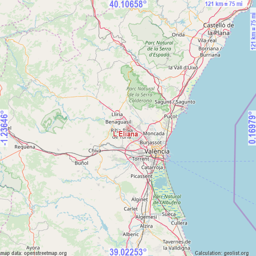
L'Eliana GPS coordinates[2]
39° 34' 0.012" North, 0° 31' 59.988" West
| Map corner | latitude | longitude |
|---|---|---|
| Upper-left | 40.10658°, | -1.23646° |
| Center: | 39.56667°, | -0.53333° |
| Lower-right: | 39.02253°, | 0.16979° |
| Map W x H: | 120.5×120.5 km | = 74.9×74.9mi |
| max Lat: | 43.74134° ⇑76.2% North |
| L'Eliana: | 39.56667° |
| min Lat: | ⇓23.8% South 27.64134° |
| min Long | L'Eliana | max Long |
| -18.00367° | -0.53333° | 4.2899° |
| W 81.3%⇐ | ⇒18.7% E |
Elevation
Elevation of L'Eliana is 91 m = 299 ft, and this is 507 m = 1663 ft below average elevation for this country.
| Max E: |
1682 m = 5518 ft | 88.3% |
| Avg. | 598 m = 1962 ft | |
| L'Eliana | 91 m = 299 ft | |
Min E: |
0 m = 0 ft | 11.7% |
See also: Spain elevation on elevation.city.
Geographical zone
L'Eliana is located in North temperate zone (between Tropic of Cancer and the Arctic Circle). Distance of this Northern Tropic circle is 1793.5 km =1114.4 mi to South.| Distance of | km | miles | from L'Eliana |
|---|---|---|---|
| North Pole | 5607.7 | 3484.5 | to North |
| Arctic Circle | 3001.8 | 1865.2 | to North |
| Tropic Cancer | 1793.5 | 1114.4 | to South |
| Equator | 4399.4 | 2733.7 | to South |


Nearby cities:
15 places around L'Eliana: (largest is in red/bold)
• Aldaia
12.9 km =8 mi,  150°
150°
• Benaguasil
5.7 km =3.5 mi,  310°
310°
• Benisanó
6.3 km =3.9 mi,  332°
332°
• Burjassot
12.1 km =7.5 mi,  121°
121°
• Bétera
6.7 km =4.2 mi,  66°
66°
• Godella
10.7 km =6.6 mi,  110°
110°
• La Pobla de Vallbona
3.9 km =2.4 mi, 331°
• Llíria
8.9 km =5.5 mi,  321°
321°
• Manises
10.3 km =6.4 mi,  144°
144°
• Moncada
12 km =7.5 mi,  101°
101°
• Paterna
10.7 km =6.6 mi,  131°
131°
• Quart de Poblet
12.4 km =7.7 mi, 139°
• Ribarroja del Turia
3.9 km =2.4 mi,  234°
234°
• Rocafort
12 km =7.5 mi, 107°
• Vilamarxant
7.8 km =4.8 mi,  272°
272°
Sources, notices
• [Note1] Compared only with cities in Spain existing in our database
• [Src1] Map data: © OpenStreetMap contributors (CC-BY-SA)
• [Src2] Other city data from geonames.org with taken over terms of usage.
• [Src3] Geographical zone / Annual Mean Temperature by Robert A. Rohde @ Wikipedia
