Macastre geodata
Macastre (Valencia) is a seat of a third-order administrative division; located in Spain in Europe/Madrid (GMT+2) time zone. With population of 1,137 people, there are 2786 cities with bigger population in this country. Compared to other cities in Spain, 77.9% of cities are located further ↑North; 79.1% of cities are located further ←West and 71.3% of cities have higher elevation than Macastre. Note1


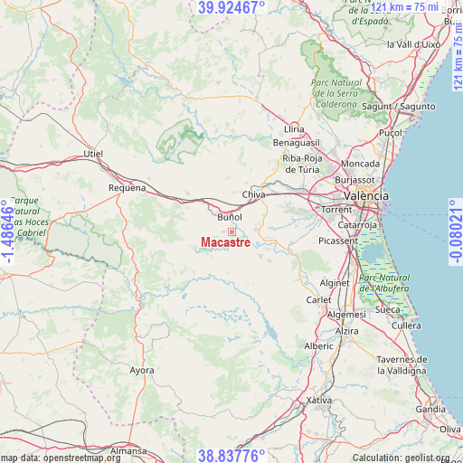
Macastre GPS coordinates[2]
39° 22' 59.988" North, 0° 46' 59.988" West
| Map corner | latitude | longitude |
|---|---|---|
| Upper-left | 39.92467°, | -1.48646° |
| Center: | 39.38333°, | -0.78333° |
| Lower-right: | 38.83776°, | -0.08021° |
| Map W x H: | 120.9×120.9 km | = 75.1×75.1mi |
| max Lat: | 43.74134° ⇑77.9% North |
| Macastre: | 39.38333° |
| min Lat: | ⇓22.1% South 27.64134° |
| min Long | Macastre | max Long |
| -18.00367° | -0.78333° | 4.2899° |
| W 79.1%⇐ | ⇒20.9% E |
Elevation
Elevation of Macastre is 361 m = 1184 ft, and this is 237 m = 778 ft below average elevation for this country.
| Max E: |
1682 m = 5518 ft | 71.3% |
| Avg. | 598 m = 1962 ft | |
| Macastre | 361 m = 1184 ft | |
Min E: |
0 m = 0 ft | 28.7% |
See also: Spain elevation on elevation.city.
Geographical zone
Macastre is located in North temperate zone (between Tropic of Cancer and the Arctic Circle). Distance of this Northern Tropic circle is 1773.1 km =1101.8 mi to South.| Distance of | km | miles | from Macastre |
|---|---|---|---|
| North Pole | 5628 | 3497.1 | to North |
| Arctic Circle | 3022.2 | 1877.9 | to North |
| Tropic Cancer | 1773.1 | 1101.8 | to South |
| Equator | 4379 | 2721 | to South |


Nearby cities:
15 places around Macastre: (largest is in red/bold)
• Alborache
1.4 km =0.9 mi,  90°
90°
• Buñol
3.7 km =2.3 mi,  0°
0°
• Cheste
14 km =8.7 mi,  37°
37°
• Chiva
10.9 km =6.8 mi,  31°
31°
• Cortes de Pallás
19.7 km =12.2 mi,  221°
221°
• Dos Aguas
11.2 km =7 mi,  187°
187°
• Godelleta
9.4 km =5.8 mi,  66°
66°
• Llombai
21.7 km =13.5 mi,  120°
120°
• Millares
14.9 km =9.3 mi,  174°
174°
• Monserrat
15.9 km =9.9 mi,  96°
96°
• Montroy
15.4 km =9.6 mi,  111°
111°
• Real de Montroi
16.7 km =10.4 mi, 109°
• Siete Aguas
14.7 km =9.1 mi,  308°
308°
• Turís
7.2 km =4.5 mi, 90°
• Yátova
1.4 km =0.9 mi,  270°
270°
Sources, notices
• [Note1] Compared only with cities in Spain existing in our database
• [Src1] Map data: © OpenStreetMap contributors (CC-BY-SA)
• [Src2] Other city data from geonames.org with taken over terms of usage.
• [Src3] Geographical zone / Annual Mean Temperature by Robert A. Rohde @ Wikipedia
