La Pobla de Vallbona geodata
La Pobla de Vallbona (Valencia) is a populated place; located in Spain in Europe/Madrid (GMT+2) time zone. With population of 20,431 people, there are 470 cities with bigger population in this country. Compared to other cities in Spain, 75.8% of cities are located further ↑North; 81.1% of cities are located further ←West and 86.8% of cities have higher elevation than La Pobla de Vallbona. Note1
Administrative division(s):
- Level 1: Valencia
- Level 2: Província de València
- Level 3: Pobla de Vallbona, la


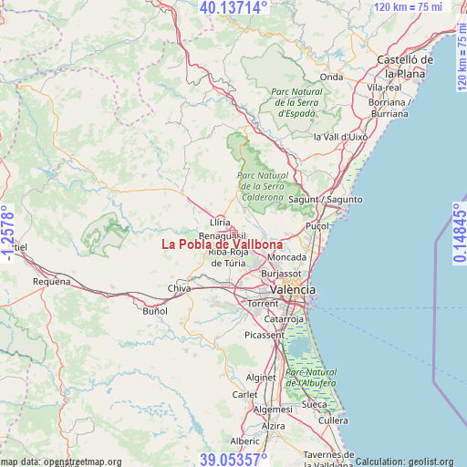
La Pobla de Vallbona GPS coordinates[2]
39° 35' 50.892" North, 0° 33' 16.848" West
| Map corner | latitude | longitude |
|---|---|---|
| Upper-left | 40.13714°, | -1.2578° |
| Center: | 39.59747°, | -0.55468° |
| Lower-right: | 39.05357°, | 0.14845° |
| Map W x H: | 120.5×120.5 km | = 74.9×74.9mi |
| max Lat: | 43.74134° ⇑75.8% North |
| La Pobla de Vallbona: | 39.59747° |
| min Lat: | ⇓24.2% South 27.64134° |
| min Long | La Pobla de Val | max Long |
| -18.00367° | -0.55468° | 4.2899° |
| W 81.1%⇐ | ⇒18.9% E |
Elevation
Elevation of La Pobla de Vallbona is 112 m = 367 ft, and this is 486 m = 1594 ft below average elevation for this country.
| Max E: |
1682 m = 5518 ft | 86.8% |
| Avg. | 598 m = 1962 ft | |
| La Pobla de Vallbona | 112 m = 367 ft | |
Min E: |
0 m = 0 ft | 13.2% |
See also: Spain elevation on elevation.city.
Geographical zone
La Pobla de Vallbona is located in North temperate zone (between Tropic of Cancer and the Arctic Circle). Distance of this Northern Tropic circle is 1796.9 km =1116.5 mi to South.| Distance of | km | miles | from La Pobla de Vallbona |
|---|---|---|---|
| North Pole | 5604.2 | 3482.3 | to North |
| Arctic Circle | 2998.3 | 1863.1 | to North |
| Tropic Cancer | 1796.9 | 1116.5 | to South |
| Equator | 4402.8 | 2735.8 | to South |


Nearby cities:
15 places around La Pobla de Vallbona: (largest is in red/bold)
• Benaguasil
2.5 km =1.6 mi,  276°
276°
• Benisanó
2.4 km =1.5 mi,  334°
334°
• Bétera
8 km =5 mi,  95°
95°
• Domeño
12.2 km =7.6 mi,  305°
305°
• Godella
13.8 km =8.6 mi,  121°
121°
• L'Eliana
3.9 km =2.4 mi,  151°
151°
• Llíria
5.1 km =3.2 mi, 313°
• Manises
14.2 km =8.8 mi, 146°
• Náquera
13.2 km =8.2 mi,  63°
63°
• Olocau
11.5 km =7.1 mi,  9°
9°
• Paterna
14.4 km =8.9 mi,  137°
137°
• Pedralba
13.9 km =8.6 mi,  271°
271°
• Ribarroja del Turia
5.9 km =3.7 mi,  193°
193°
• Serra
14.1 km =8.8 mi,  47°
47°
• Vilamarxant
6.8 km =4.2 mi,  242°
242°
Sources, notices
• [Note1] Compared only with cities in Spain existing in our database
• [Src1] Map data: © OpenStreetMap contributors (CC-BY-SA)
• [Src2] Other city data from geonames.org with taken over terms of usage.
• [Src3] Geographical zone / Annual Mean Temperature by Robert A. Rohde @ Wikipedia
