Casarabonela geodata
Casarabonela (Andalusia) is a seat of a third-order administrative division; located in Spain in Europe/Madrid (GMT+2) time zone. With population of 2,490 people, there are 1906 cities with bigger population in this country. Compared to other cities in Spain, 96.9% of cities are located further ↑North; 70.3% of cities are located further →East and 63.6% of cities have higher elevation than Casarabonela. Note1


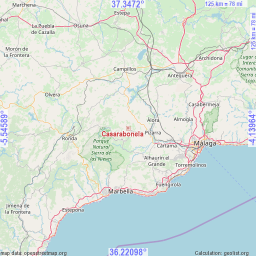
Casarabonela GPS coordinates[2]
36° 47' 10.176" North, 4° 50' 33.936" West
| Map corner | latitude | longitude |
|---|---|---|
| Upper-left | 37.3472°, | -5.54589° |
| Center: | 36.78616°, | -4.84276° |
| Lower-right: | 36.22098°, | -4.13964° |
| Map W x H: | 125.2×125.2 km | = 77.8×77.8mi |
| max Lat: | 43.74134° ⇑96.9% North |
| Casarabonela: | 36.78616° |
| min Lat: | ⇓3.1% South 27.64134° |
| min Long | Casarabonela | max Long |
| -18.00367° | -4.84276° | 4.2899° |
| W 29.7%⇐ | ⇒70.3% E |
Elevation
Elevation of Casarabonela is 480 m = 1575 ft, and this is 118 m = 387 ft below average elevation for this country.
| Max E: |
1682 m = 5518 ft | 63.6% |
| Avg. | 598 m = 1962 ft | |
| Casarabonela | 480 m = 1575 ft | |
Min E: |
0 m = 0 ft | 36.4% |
See also: Spain elevation on elevation.city.
Geographical zone
Casarabonela is located in North temperate zone (between Tropic of Cancer and the Arctic Circle). Distance of this Northern Tropic circle is 1484.3 km =922.3 mi to South.| Distance of | km | miles | from Casarabonela |
|---|---|---|---|
| North Pole | 5916.8 | 3676.5 | to North |
| Arctic Circle | 3310.9 | 2057.3 | to North |
| Tropic Cancer | 1484.3 | 922.3 | to South |
| Equator | 4090.2 | 2541.5 | to South |


Nearby cities:
15 places around Casarabonela: (largest is in red/bold)
• Alhaurín el Grande
21.1 km =13.1 mi,  138°
138°
• Alora
12.9 km =8 mi,  71°
71°
• Alozaina
6.7 km =4.2 mi,  191°
191°
• Ardales
10.2 km =6.3 mi,  357°
357°
• Carratraca
7.7 km =4.8 mi,  15°
15°
• Coín
16.1 km =10 mi,  151°
151°
• Cuevas del Becerro
20.5 km =12.7 mi,  298°
298°
• Cártama
20.5 km =12.7 mi,  114°
114°
• Estación de Cártama
21 km =13 mi, 106°
• Guaro
14.5 km =9 mi,  177°
177°
• Monda
17.4 km =10.8 mi, 176°
• Pizarra
12.2 km =7.6 mi,  100°
100°
• Serrato
16.6 km =10.3 mi,  311°
311°
• Tolox
12.3 km =7.6 mi,  206°
206°
• Yunquera
9.2 km =5.7 mi,  229°
229°
Sources, notices
• [Note1] Compared only with cities in Spain existing in our database
• [Src1] Map data: © OpenStreetMap contributors (CC-BY-SA)
• [Src2] Other city data from geonames.org with taken over terms of usage.
• [Src3] Geographical zone / Annual Mean Temperature by Robert A. Rohde @ Wikipedia
