Alhaurín el Grande geodata
Alhaurín el Grande (Andalusia) is a seat of a third-order administrative division; located in Spain in Europe/Madrid (GMT+2) time zone. With population of 23,319 people, there are 399 cities with bigger population in this country. Compared to other cities in Spain, 97.6% of cities are located further ↑North; 68.5% of cities are located further →East and 78.4% of cities have higher elevation than Alhaurín el Grande. Note1
Administrative division(s):
- Level 1: Andalusia
- Level 2: Provincia de Málaga
- Level 3: Alhaurín el Grande


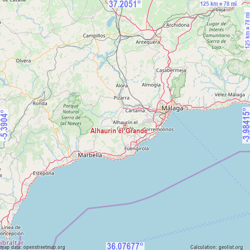
Alhaurín el Grande GPS coordinates[2]
36° 38' 34.8" North, 4° 41' 14.208" West
| Map corner | latitude | longitude |
|---|---|---|
| Upper-left | 37.2051°, | -5.3904° |
| Center: | 36.643°, | -4.68728° |
| Lower-right: | 36.07677°, | -3.98415° |
| Map W x H: | 125.5×125.5 km | = 78×78mi |
| max Lat: | 43.74134° ⇑97.6% North |
| Alhaurín el Grande: | 36.643° |
| min Lat: | ⇓2.4% South 27.64134° |
| min Long | Alhaurín el Gr | max Long |
| -18.00367° | -4.68728° | 4.2899° |
| W 31.5%⇐ | ⇒68.5% E |
Elevation
Elevation of Alhaurín el Grande is 249 m = 817 ft, and this is 349 m = 1145 ft below average elevation for this country.
| Max E: |
1682 m = 5518 ft | 78.4% |
| Avg. | 598 m = 1962 ft | |
| Alhaurín el Grande | 249 m = 817 ft | |
Min E: |
0 m = 0 ft | 21.6% |
See also: Spain elevation on elevation.city.
Geographical zone
Alhaurín el Grande is located in North temperate zone (between Tropic of Cancer and the Arctic Circle). Distance of this Northern Tropic circle is 1468.4 km =912.4 mi to South.| Distance of | km | miles | from Alhaurín el Grande |
|---|---|---|---|
| North Pole | 5932.7 | 3686.4 | to North |
| Arctic Circle | 3326.9 | 2067.2 | to North |
| Tropic Cancer | 1468.4 | 912.4 | to South |
| Equator | 4074.3 | 2531.7 | to South |


Nearby cities:
15 places around Alhaurín el Grande: (largest is in red/bold)
• Alhaurín de la Torre
11.5 km =7.1 mi,  78°
78°
• Alora
20.1 km =12.5 mi,  355°
355°
• Alozaina
17.9 km =11.1 mi,  301°
301°
• Benalmádena
11.5 km =7.1 mi,  117°
117°
• Coín
6.4 km =4 mi,  286°
286°
• Cártama
8.9 km =5.5 mi,  32°
32°
• Estación de Cártama
11.9 km =7.4 mi, 32°
• Fuengirola
12.7 km =7.9 mi,  154°
154°
• Guaro
13.2 km =8.2 mi,  276°
276°
• Mijas
6.9 km =4.3 mi,  139°
139°
• Monda
13 km =8.1 mi,  263°
263°
• Ojén
17.4 km =10.8 mi,  239°
239°
• Pizarra
13.7 km =8.5 mi,  352°
352°
• Tolox
20 km =12.4 mi, 284°
• Torremolinos
16.9 km =10.5 mi,  98°
98°
Sources, notices
• [Note1] Compared only with cities in Spain existing in our database
• [Src1] Map data: © OpenStreetMap contributors (CC-BY-SA)
• [Src2] Other city data from geonames.org with taken over terms of usage.
• [Src3] Geographical zone / Annual Mean Temperature by Robert A. Rohde @ Wikipedia
