Serrato geodata
Serrato (Andalusia) is a seat of a third-order administrative division; located in Spain in Europe/Madrid (GMT+2) time zone. In our database, there are 6762 cities with bigger population. Compared to other cities in Spain, 96.1% of cities are located further ↑North; 72.3% of cities are located further →East and 59.8% of cities have higher elevation than Serrato. Note1


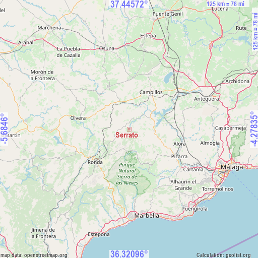
Serrato GPS coordinates[2]
36° 53' 7.476" North, 4° 58' 53.292" West
| Map corner | latitude | longitude |
|---|---|---|
| Upper-left | 37.44572°, | -5.6846° |
| Center: | 36.88541°, | -4.98147° |
| Lower-right: | 36.32096°, | -4.27835° |
| Map W x H: | 125.1×125.1 km | = 77.7×77.7mi |
| max Lat: | 43.74134° ⇑96.1% North |
| Serrato: | 36.88541° |
| min Lat: | ⇓3.9% South 27.64134° |
| min Long | Serrato | max Long |
| -18.00367° | -4.98147° | 4.2899° |
| W 27.7%⇐ | ⇒72.3% E |
Elevation
Elevation of Serrato is 531 m = 1742 ft, and this is 67 m = 220 ft below average elevation for this country.
| Max E: |
1682 m = 5518 ft | 59.8% |
| Avg. | 598 m = 1962 ft | |
| Serrato | 531 m = 1742 ft | |
Min E: |
0 m = 0 ft | 40.2% |
See also: Spain elevation on elevation.city.
Geographical zone
Serrato is located in North temperate zone (between Tropic of Cancer and the Arctic Circle). Distance of this Northern Tropic circle is 1495.4 km =929.2 mi to South.| Distance of | km | miles | from Serrato |
|---|---|---|---|
| North Pole | 5905.8 | 3669.7 | to North |
| Arctic Circle | 3299.9 | 2050.5 | to North |
| Tropic Cancer | 1495.4 | 929.2 | to South |
| Equator | 4101.3 | 2548.4 | to South |


Nearby cities:
15 places around Serrato: (largest is in red/bold)
• Alcalá del Valle
17.1 km =10.6 mi,  277°
277°
• Algámitas
20.8 km =12.9 mi,  314°
314°
• Almargen
13.5 km =8.4 mi,  344°
344°
• Alozaina
20.7 km =12.9 mi,  147°
147°
• Ardales
12 km =7.5 mi,  93°
93°
• Arriate
17.1 km =10.6 mi,  236°
236°
• Campillos
20.9 km =13 mi,  30°
30°
• Carratraca
14.8 km =9.2 mi,  104°
104°
• Casarabonela
16.6 km =10.3 mi,  131°
131°
• Cañete la Real
8.3 km =5.2 mi,  332°
332°
• Cuevas del Becerro
5.7 km =3.5 mi,  258°
258°
• Setenil de las Bodegas
18 km =11.2 mi, 262°
• Teba
12.2 km =7.6 mi, 26°
• Torre Alháquime
22.7 km =14.1 mi, 278°
• Yunquera
17.8 km =11.1 mi,  162°
162°
Sources, notices
• [Note1] Compared only with cities in Spain existing in our database
• [Src1] Map data: © OpenStreetMap contributors (CC-BY-SA)
• [Src2] Other city data from geonames.org with taken over terms of usage.
• [Src3] Geographical zone / Annual Mean Temperature by Robert A. Rohde @ Wikipedia
