Carratraca geodata
Carratraca (Andalusia) is a seat of a third-order administrative division; located in Spain in Europe/Madrid (GMT+2) time zone. With population of 849 people, there are 3132 cities with bigger population in this country. Compared to other cities in Spain, 96.4% of cities are located further ↑North; 69.9% of cities are located further →East and 59.8% of cities have higher elevation than Carratraca. Note1


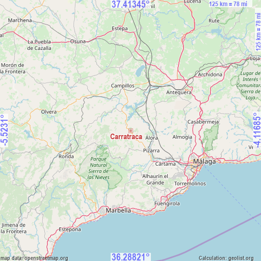
Carratraca GPS coordinates[2]
36° 51' 10.44" North, 4° 49' 11.928" West
| Map corner | latitude | longitude |
|---|---|---|
| Upper-left | 37.41345°, | -5.5231° |
| Center: | 36.8529°, | -4.81998° |
| Lower-right: | 36.28821°, | -4.11685° |
| Map W x H: | 125.1×125.1 km | = 77.7×77.7mi |
| max Lat: | 43.74134° ⇑96.4% North |
| Carratraca: | 36.8529° |
| min Lat: | ⇓3.6% South 27.64134° |
| min Long | Carratraca | max Long |
| -18.00367° | -4.81998° | 4.2899° |
| W 30.1%⇐ | ⇒69.9% E |
Elevation
Elevation of Carratraca is 531 m = 1742 ft, and this is 67 m = 220 ft below average elevation for this country.
| Max E: |
1682 m = 5518 ft | 59.8% |
| Avg. | 598 m = 1962 ft | |
| Carratraca | 531 m = 1742 ft | |
Min E: |
0 m = 0 ft | 40.2% |
See also: Spain elevation on elevation.city.
Geographical zone
Carratraca is located in North temperate zone (between Tropic of Cancer and the Arctic Circle). Distance of this Northern Tropic circle is 1491.7 km =926.9 mi to South.| Distance of | km | miles | from Carratraca |
|---|---|---|---|
| North Pole | 5909.4 | 3671.9 | to North |
| Arctic Circle | 3303.5 | 2052.7 | to North |
| Tropic Cancer | 1491.7 | 926.9 | to South |
| Equator | 4097.7 | 2546.2 | to South |


Nearby cities:
15 places around Carratraca: (largest is in red/bold)
• Alora
10.7 km =6.6 mi,  107°
107°
• Alozaina
14.4 km =8.9 mi,  193°
193°
• Ardales
3.7 km =2.3 mi,  319°
319°
• Campillos
22.1 km =13.7 mi,  350°
350°
• Casarabonela
7.7 km =4.8 mi,  195°
195°
• Cañete la Real
21.2 km =13.2 mi,  301°
301°
• Coín
22.2 km =13.8 mi,  165°
165°
• Cuevas del Becerro
20.2 km =12.6 mi,  277°
277°
• Estación de Cártama
22.5 km =14 mi,  126°
126°
• Guaro
21.9 km =13.6 mi,  183°
183°
• Pizarra
13.9 km =8.6 mi, 134°
• Serrato
14.8 km =9.2 mi, 284°
• Teba
17 km =10.6 mi,  328°
328°
• Tolox
19.9 km =12.4 mi, 202°
• Yunquera
16.1 km =10 mi,  213°
213°
Sources, notices
• [Note1] Compared only with cities in Spain existing in our database
• [Src1] Map data: © OpenStreetMap contributors (CC-BY-SA)
• [Src2] Other city data from geonames.org with taken over terms of usage.
• [Src3] Geographical zone / Annual Mean Temperature by Robert A. Rohde @ Wikipedia
