Cañada del Hoyo geodata
Cañada del Hoyo (Castille-La Mancha) is a seat of a third-order administrative division; located in Spain in Europe/Madrid (GMT+2) time zone. With population of 321 people, there are 4419 cities with bigger population in this country. Compared to other cities in Spain, 70.7% of cities are located further ↑North; 68.4% of cities are located further ←West and 88.2% of cities have lower elevation than Cañada del Hoyo. Note1
Administrative division(s):
- Level 1: Castille-La Mancha
- Level 2: Provincia de Cuenca
- Level 3: Cañada del Hoyo


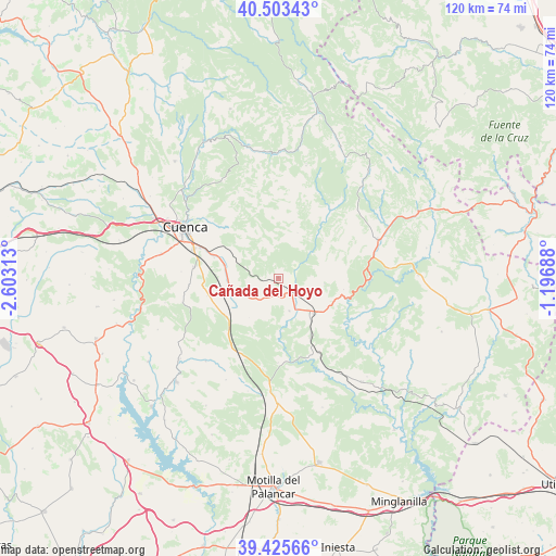
Cañada del Hoyo GPS coordinates[2]
39° 58' 0.012" North, 1° 54' 0" West
| Map corner | latitude | longitude |
|---|---|---|
| Upper-left | 40.50343°, | -2.60313° |
| Center: | 39.96667°, | -1.9° |
| Lower-right: | 39.42566°, | -1.19688° |
| Map W x H: | 119.8×119.8 km | = 74.4×74.4mi |
| max Lat: | 43.74134° ⇑70.7% North |
| Cañada del Hoyo: | 39.96667° |
| min Lat: | ⇓29.3% South 27.64134° |
| min Long | Cañada del Hoy | max Long |
| -18.00367° | -1.9° | 4.2899° |
| W 68.4%⇐ | ⇒31.6% E |
Elevation
Elevation of Cañada del Hoyo is 1001 m = 3284 ft, and this is 403 m = 1322 ft above average elevation for this country.
| Max E: |
1682 m = 5518 ft | 11.8% |
| Cañada del Hoyo | 1001 m 3284 ft | |
| Avg. | 598 m = 1962 ft | |
Min E: |
0 m = 0 ft | 88.2% |
See also: Spain elevation on elevation.city.
Geographical zone
Cañada del Hoyo is located in North temperate zone (between Tropic of Cancer and the Arctic Circle). Distance of this Northern Tropic circle is 1838 km =1142.1 mi to South.| Distance of | km | miles | from Cañada del Hoyo |
|---|---|---|---|
| North Pole | 5563.2 | 3456.8 | to North |
| Arctic Circle | 2957.3 | 1837.6 | to North |
| Tropic Cancer | 1838 | 1142.1 | to South |
| Equator | 4443.9 | 2761.3 | to South |


Nearby cities:
15 places around Cañada del Hoyo: (largest is in red/bold)
• Arguisuelas
16.4 km =10.2 mi,  154°
154°
• Boniches
24.2 km =15 mi,  85°
85°
• Campillos-Sierra
22.6 km =14 mi,  48°
48°
• Carboneras de Guadazaón
12.6 km =7.8 mi,  137°
137°
• Cañete
23.2 km =14.4 mi,  66°
66°
• Chumillas
25 km =15.5 mi,  207°
207°
• Cuenca
22.8 km =14.2 mi,  299°
299°
• Fuentes
9.9 km =6.2 mi,  270°
270°
• Monteagudo de las Salinas
18.5 km =11.5 mi,  180°
180°
• Olmeda del Rey
24.3 km =15.1 mi,  220°
220°
• Pajaroncillo
14.3 km =8.9 mi,  97°
97°
• Pajarón
10.1 km =6.3 mi, 100°
• Reíllo
7.9 km =4.9 mi,  159°
159°
• Valdemorillo de la Sierra
12.4 km =7.7 mi, 53°
• Valdemoro-Sierra
18.7 km =11.6 mi,  37°
37°
Sources, notices
• [Note1] Compared only with cities in Spain existing in our database
• [Src1] Map data: © OpenStreetMap contributors (CC-BY-SA)
• [Src2] Other city data from geonames.org with taken over terms of usage.
• [Src3] Geographical zone / Annual Mean Temperature by Robert A. Rohde @ Wikipedia
