Fuentes geodata
Fuentes (Castille-La Mancha) is a seat of a third-order administrative division; located in Spain in Europe/Madrid (GMT+2) time zone. With population of 503 people, there are 3875 cities with bigger population in this country. Compared to other cities in Spain, 70.7% of cities are located further ↑North; 67.3% of cities are located further ←West and 91.3% of cities have lower elevation than Fuentes. Note1
Administrative division(s):
- Level 1: Castille-La Mancha
- Level 2: Provincia de Cuenca
- Level 3: Fuentes


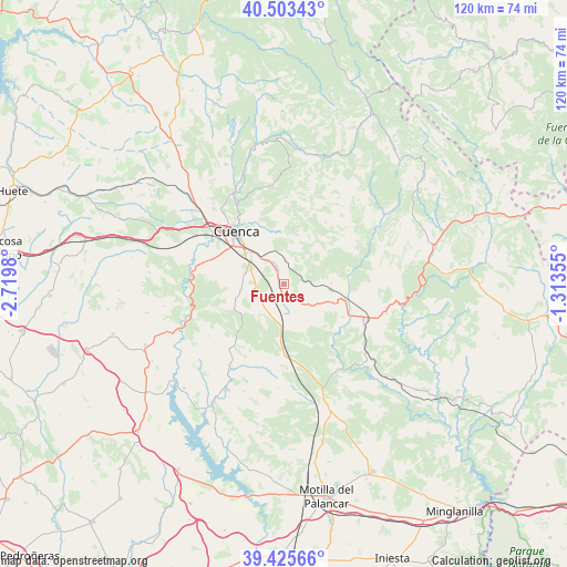
Fuentes GPS coordinates[2]
39° 58' 0.012" North, 2° 1' 0.012" West
| Map corner | latitude | longitude |
|---|---|---|
| Upper-left | 40.50343°, | -2.7198° |
| Center: | 39.96667°, | -2.01667° |
| Lower-right: | 39.42566°, | -1.31355° |
| Map W x H: | 119.8×119.8 km | = 74.4×74.4mi |
| max Lat: | 43.74134° ⇑70.7% North |
| Fuentes: | 39.96667° |
| min Lat: | ⇓29.3% South 27.64134° |
| min Long | Fuentes | max Long |
| -18.00367° | -2.01667° | 4.2899° |
| W 67.3%⇐ | ⇒32.7% E |
Elevation
Elevation of Fuentes is 1053 m = 3455 ft, and this is 455 m = 1493 ft above average elevation for this country.
| Max E: |
1682 m = 5518 ft | 8.7% |
| Fuentes | 1053 m 3455 ft | |
| Avg. | 598 m = 1962 ft | |
Min E: |
0 m = 0 ft | 91.3% |
See also: Spain elevation on elevation.city.
Geographical zone
Fuentes is located in North temperate zone (between Tropic of Cancer and the Arctic Circle). Distance of this Northern Tropic circle is 1838 km =1142.1 mi to South.| Distance of | km | miles | from Fuentes |
|---|---|---|---|
| North Pole | 5563.2 | 3456.8 | to North |
| Arctic Circle | 2957.3 | 1837.6 | to North |
| Tropic Cancer | 1838 | 1142.1 | to South |
| Equator | 4443.9 | 2761.3 | to South |


Nearby cities:
15 places around Fuentes: (largest is in red/bold)
• Albaladejo del Cuende
25.4 km =15.8 mi,  225°
225°
• Arguisuelas
22.6 km =14 mi,  130°
130°
• Carboneras de Guadazaón
20.7 km =12.9 mi,  116°
116°
• Cañada del Hoyo
9.9 km =6.2 mi,  90°
90°
• Chillarón de Cuenca
23.3 km =14.5 mi,  311°
311°
• Chumillas
22.3 km =13.9 mi,  183°
183°
• Cuenca
14.9 km =9.3 mi,  318°
318°
• Mariana
24.9 km =15.5 mi,  333°
333°
• Monteagudo de las Salinas
21 km =13 mi,  151°
151°
• Olmeda del Rey
19.4 km =12.1 mi,  197°
197°
• Pajaroncillo
24.2 km =15 mi, 94°
• Pajarón
20 km =12.4 mi,  95°
95°
• Reíllo
14.8 km =9.2 mi, 120°
• Valdemorillo de la Sierra
21.2 km =13.2 mi,  69°
69°
• Villar de Olalla
16.2 km =10.1 mi,  289°
289°
Sources, notices
• [Note1] Compared only with cities in Spain existing in our database
• [Src1] Map data: © OpenStreetMap contributors (CC-BY-SA)
• [Src2] Other city data from geonames.org with taken over terms of usage.
• [Src3] Geographical zone / Annual Mean Temperature by Robert A. Rohde @ Wikipedia
