Reíllo geodata
Reíllo (Castille-La Mancha) is a seat of a third-order administrative division; located in Spain in Europe/Madrid (GMT+2) time zone. With population of 118 people, there are 5722 cities with bigger population in this country. Compared to other cities in Spain, 71.6% of cities are located further ↑North; 68.8% of cities are located further ←West and 86.6% of cities have lower elevation than Reíllo. Note1
Administrative division(s):
- Level 1: Castille-La Mancha
- Level 2: Provincia de Cuenca
- Level 3: Reíllo


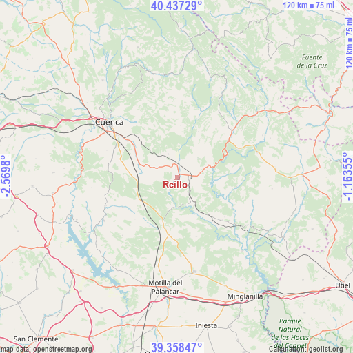
Reíllo GPS coordinates[2]
39° 54' 0" North, 1° 52' 0.012" West
| Map corner | latitude | longitude |
|---|---|---|
| Upper-left | 40.43729°, | -2.5698° |
| Center: | 39.9°, | -1.86667° |
| Lower-right: | 39.35847°, | -1.16355° |
| Map W x H: | 120×120 km | = 74.6×74.6mi |
| max Lat: | 43.74134° ⇑71.6% North |
| Reíllo: | 39.9° |
| min Lat: | ⇓28.4% South 27.64134° |
| min Long | Reíllo | max Long |
| -18.00367° | -1.86667° | 4.2899° |
| W 68.8%⇐ | ⇒31.2% E |
Elevation
Elevation of Reíllo is 974 m = 3196 ft, and this is 376 m = 1234 ft above average elevation for this country.
| Max E: |
1682 m = 5518 ft | 13.4% |
| Reíllo | 974 m 3196 ft | |
| Avg. | 598 m = 1962 ft | |
Min E: |
0 m = 0 ft | 86.6% |
See also: Spain elevation on elevation.city.
Geographical zone
Reíllo is located in North temperate zone (between Tropic of Cancer and the Arctic Circle). Distance of this Northern Tropic circle is 1830.5 km =1137.4 mi to South.| Distance of | km | miles | from Reíllo |
|---|---|---|---|
| North Pole | 5570.6 | 3461.4 | to North |
| Arctic Circle | 2964.7 | 1842.2 | to North |
| Tropic Cancer | 1830.5 | 1137.4 | to South |
| Equator | 4436.5 | 2756.7 | to South |


Nearby cities:
15 places around Reíllo: (largest is in red/bold)
• Almodóvar del Pinar
20.4 km =12.7 mi,  183°
183°
• Arguisuelas
8.6 km =5.3 mi,  150°
150°
• Carboneras de Guadazaón
6 km =3.7 mi,  108°
108°
• Cardenete
21.6 km =13.4 mi,  133°
133°
• Cañada del Hoyo
7.9 km =4.9 mi,  339°
339°
• Chumillas
20.5 km =12.7 mi,  223°
223°
• Fuentes
14.8 km =9.2 mi,  300°
300°
• Monteagudo de las Salinas
11.5 km =7.1 mi,  194°
194°
• Olmeda del Rey
21.6 km =13.4 mi,  238°
238°
• Pajaroncillo
12.7 km =7.9 mi,  63°
63°
• Pajarón
9 km =5.6 mi,  51°
51°
• Paracuellos
21.6 km =13.4 mi,  160°
160°
• Valdemorillo de la Sierra
16.4 km =10.2 mi,  25°
25°
• Villar del Humo
20.3 km =12.6 mi,  100°
100°
• Yémeda
19.6 km =12.2 mi,  139°
139°
Sources, notices
• [Note1] Compared only with cities in Spain existing in our database
• [Src1] Map data: © OpenStreetMap contributors (CC-BY-SA)
• [Src2] Other city data from geonames.org with taken over terms of usage.
• [Src3] Geographical zone / Annual Mean Temperature by Robert A. Rohde @ Wikipedia
