Cadiz geodata
Cadiz (Andalusia) is a seat of a second-order administrative division; located in Spain in Europe/Madrid (GMT+2) time zone. With population of 126,766 people, there are 71 cities with bigger population in this country. Compared to other cities in Spain, 98% of cities are located further ↑North; 89.4% of cities are located further →East and 95.6% of cities have higher elevation than Cadiz. Note1


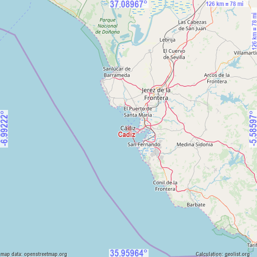
Cadiz GPS coordinates[2]
36° 31' 36.192" North, 6° 17' 20.76" West
| Map corner | latitude | longitude |
|---|---|---|
| Upper-left | 37.08967°, | -6.99222° |
| Center: | 36.52672°, | -6.2891° |
| Lower-right: | 35.95964°, | -5.58597° |
| Map W x H: | 125.6×125.6 km | = 78×78mi |
| max Lat: | 43.74134° ⇑98% North |
| Cadiz: | 36.52672° |
| min Lat: | ⇓2% South 27.64134° |
| min Long | Cadiz | max Long |
| -18.00367° | -6.2891° | 4.2899° |
| W 10.6%⇐ | ⇒89.4% E |
Elevation
Elevation of Cadiz is 22 m = 72 ft, and this is 576 m = 1890 ft below average elevation for this country.
| Max E: |
1682 m = 5518 ft | 95.6% |
| Avg. | 598 m = 1962 ft | |
| Cadiz | 22 m = 72 ft | |
Min E: |
0 m = 0 ft | 4.4% |
See also: Cadiz elevation on elevation.city.
Geographical zone
Cadiz is located in North temperate zone (between Tropic of Cancer and the Arctic Circle). Distance of this Northern Tropic circle is 1455.5 km =904.4 mi to South.| Distance of | km | miles | from Cadiz |
|---|---|---|---|
| North Pole | 5945.7 | 3694.5 | to North |
| Arctic Circle | 3339.8 | 2075.3 | to North |
| Tropic Cancer | 1455.5 | 904.4 | to South |
| Equator | 4061.4 | 2523.6 | to South |


Nearby cities:
15 places around Cadiz: (largest is in red/bold)
• Chiclana de la Frontera
17.6 km =10.9 mi,  132°
132°
• Chipiona
26.8 km =16.7 mi,  330°
330°
• Conil de la Frontera
33 km =20.5 mi,  147°
147°
• El Cuervo
42.6 km =26.5 mi,  31°
31°
• El Puerto de Santa María
9 km =5.6 mi, 33°
• Jerez de la Frontera
22.4 km =13.9 mi,  37°
37°
• Medina Sidonia
33.3 km =20.7 mi,  103°
103°
• Paterna de Rivera
37.8 km =23.5 mi,  90°
90°
• Puerto Real
8.8 km =5.5 mi, 88°
• Rota
12.8 km =8 mi, 329°
• San Fernando
9.9 km =6.2 mi,  124°
124°
• San José del Valle
44.6 km =27.7 mi,  78°
78°
• Sanlúcar de Barrameda
28.5 km =17.7 mi,  348°
348°
• Trebujena
39.6 km =24.6 mi,  14°
14°
• Vejer de la Frontera
42 km =26.1 mi,  136°
136°
In other languages:
- In Spanish: Cádiz
- In France: Cadix
- In German: Cádiz
- In Italian: Cádice, Cadice
- In Russian: Кадис
- In Chinese: 加的斯
Sources, notices
• [Note1] Compared only with cities in Spain existing in our database
• [Src1] Map data: © OpenStreetMap contributors (CC-BY-SA)
• [Src2] Other city data from geonames.org with taken over terms of usage.
• [Src3] Geographical zone / Annual Mean Temperature by Robert A. Rohde @ Wikipedia
