El Cuervo geodata
El Cuervo (Andalusia) is a populated place; located in Spain in Europe/Madrid (GMT+2) time zone. With population of 7,745 people, there are 958 cities with bigger population in this country. Compared to other cities in Spain, 96.4% of cities are located further ↑North; 86.5% of cities are located further →East and 90.2% of cities have higher elevation than El Cuervo. Note1
Administrative division(s):
- Level 1: Andalusia
- Level 2: Provincia de Sevilla
- Level 3: Cuervo de Sevilla, El


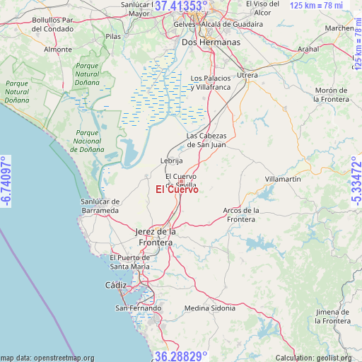
El Cuervo GPS coordinates[2]
36° 51' 10.728" North, 6° 2' 16.26" West
| Map corner | latitude | longitude |
|---|---|---|
| Upper-left | 37.41353°, | -6.74097° |
| Center: | 36.85298°, | -6.03785° |
| Lower-right: | 36.28829°, | -5.33472° |
| Map W x H: | 125.1×125.1 km | = 77.7×77.7mi |
| max Lat: | 43.74134° ⇑96.4% North |
| El Cuervo: | 36.85298° |
| min Lat: | ⇓3.6% South 27.64134° |
| min Long | El Cuervo | max Long |
| -18.00367° | -6.03785° | 4.2899° |
| W 13.5%⇐ | ⇒86.5% E |
Elevation
Elevation of El Cuervo is 62 m = 203 ft, and this is 536 m = 1759 ft below average elevation for this country.
| Max E: |
1682 m = 5518 ft | 90.2% |
| Avg. | 598 m = 1962 ft | |
| El Cuervo | 62 m = 203 ft | |
Min E: |
0 m = 0 ft | 9.8% |
See also: Spain elevation on elevation.city.
Geographical zone
El Cuervo is located in North temperate zone (between Tropic of Cancer and the Arctic Circle). Distance of this Northern Tropic circle is 1491.7 km =926.9 mi to South.| Distance of | km | miles | from El Cuervo |
|---|---|---|---|
| North Pole | 5909.4 | 3671.9 | to North |
| Arctic Circle | 3303.5 | 2052.7 | to North |
| Tropic Cancer | 1491.7 | 926.9 | to South |
| Equator | 4097.7 | 2546.2 | to South |


Nearby cities:
15 places around El Cuervo: (largest is in red/bold)
• Arcos de la Frontera
23.2 km =14.4 mi,  119°
119°
• Bornos
26.4 km =16.4 mi,  98°
98°
• Chipiona
37.8 km =23.5 mi,  249°
249°
• El Puerto de Santa María
33.7 km =20.9 mi,  211°
211°
• Espera
20.8 km =12.9 mi,  83°
83°
• Jerez de la Frontera
20.5 km =12.7 mi, 205°
• Las Cabezas de San Juan
17 km =10.6 mi,  31°
31°
• Lebrija
8.2 km =5.1 mi,  336°
336°
• Los Palacios y Villafranca
35.8 km =22.2 mi,  16°
16°
• Puerto Real
38.6 km =24 mi,  200°
200°
• Rota
38.4 km =23.9 mi,  228°
228°
• San José del Valle
34.8 km =21.6 mi,  142°
142°
• Sanlúcar de Barrameda
29.1 km =18.1 mi, 253°
• Trebujena
12.4 km =7.7 mi,  279°
279°
• Villamartín
35 km =21.7 mi,  88°
88°
Sources, notices
• [Note1] Compared only with cities in Spain existing in our database
• [Src1] Map data: © OpenStreetMap contributors (CC-BY-SA)
• [Src2] Other city data from geonames.org with taken over terms of usage.
• [Src3] Geographical zone / Annual Mean Temperature by Robert A. Rohde @ Wikipedia
