Rota geodata
Rota (Andalusia) is a seat of a third-order administrative division; located in Spain in Europe/Madrid (GMT+2) time zone. With population of 29,179 people, there are 318 cities with bigger population in this country. Compared to other cities in Spain, 97.7% of cities are located further ↑North; 90% of cities are located further →East and 96.4% of cities have higher elevation than Rota. Note1


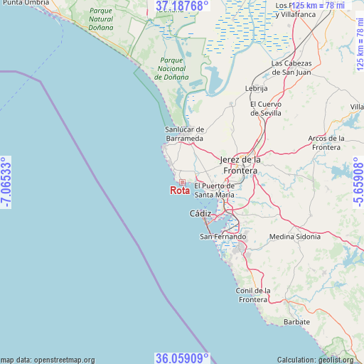
Rota GPS coordinates[2]
36° 37' 31.62" North, 6° 21' 43.92" West
| Map corner | latitude | longitude |
|---|---|---|
| Upper-left | 37.18768°, | -7.06533° |
| Center: | 36.62545°, | -6.3622° |
| Lower-right: | 36.05909°, | -5.65908° |
| Map W x H: | 125.5×125.5 km | = 78×78mi |
| max Lat: | 43.74134° ⇑97.7% North |
| Rota: | 36.62545° |
| min Lat: | ⇓2.3% South 27.64134° |
| min Long | Rota | max Long |
| -18.00367° | -6.3622° | 4.2899° |
| W 10%⇐ | ⇒90% E |
Elevation
Elevation of Rota is 18 m = 59 ft, and this is 580 m = 1903 ft below average elevation for this country.
| Max E: |
1682 m = 5518 ft | 96.4% |
| Avg. | 598 m = 1962 ft | |
| Rota | 18 m = 59 ft | |
Min E: |
0 m = 0 ft | 3.6% |
See also: Spain elevation on elevation.city.
Geographical zone
Rota is located in North temperate zone (between Tropic of Cancer and the Arctic Circle). Distance of this Northern Tropic circle is 1466.4 km =911.2 mi to South.| Distance of | km | miles | from Rota |
|---|---|---|---|
| North Pole | 5934.7 | 3687.7 | to North |
| Arctic Circle | 3328.8 | 2068.4 | to North |
| Tropic Cancer | 1466.4 | 911.2 | to South |
| Equator | 4072.4 | 2530.5 | to South |


Nearby cities:
15 places around Rota: (largest is in red/bold)
• Cadiz
12.8 km =8 mi,  149°
149°
• Chiclana de la Frontera
30.1 km =18.7 mi,  139°
139°
• Chipiona
14 km =8.7 mi,  331°
331°
• Conil de la Frontera
45.8 km =28.5 mi, 147°
• El Cuervo
38.4 km =23.9 mi,  48°
48°
• El Puerto de Santa María
12.1 km =7.5 mi,  106°
106°
• Jerez de la Frontera
21.3 km =13.2 mi,  71°
71°
• Lebrija
41.6 km =25.8 mi,  37°
37°
• Matalascañas
44.7 km =27.8 mi,  337°
337°
• Medina Sidonia
43.1 km =26.8 mi,  115°
115°
• Paterna de Rivera
45.8 km =28.5 mi,  104°
104°
• Puerto Real
18.8 km =11.7 mi,  125°
125°
• San Fernando
22.2 km =13.8 mi, 138°
• Sanlúcar de Barrameda
17 km =10.6 mi,  3°
3°
• Trebujena
31.9 km =19.8 mi,  31°
31°
Sources, notices
• [Note1] Compared only with cities in Spain existing in our database
• [Src1] Map data: © OpenStreetMap contributors (CC-BY-SA)
• [Src2] Other city data from geonames.org with taken over terms of usage.
• [Src3] Geographical zone / Annual Mean Temperature by Robert A. Rohde @ Wikipedia
