San Fernando geodata
San Fernando (Andalusia) is a seat of a third-order administrative division; located in Spain in Europe/Madrid (GMT+2) time zone. With population of 96,366 people, there are 92 cities with bigger population in this country. Compared to other cities in Spain, 98.1% of cities are located further ↑North; 88.5% of cities are located further →East and 97% of cities have higher elevation than San Fernando. Note1


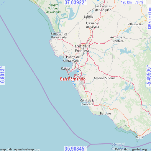
San Fernando GPS coordinates[2]
36° 28' 33.24" North, 6° 11' 53.412" West
| Map corner | latitude | longitude |
|---|---|---|
| Upper-left | 37.03922°, | -6.9013° |
| Center: | 36.4759°, | -6.19817° |
| Lower-right: | 35.90845°, | -5.49505° |
| Map W x H: | 125.7×125.7 km | = 78.1×78.1mi |
| max Lat: | 43.74134° ⇑98.1% North |
| San Fernando: | 36.4759° |
| min Lat: | ⇓1.9% South 27.64134° |
| min Long | San Fernando | max Long |
| -18.00367° | -6.19817° | 4.2899° |
| W 11.5%⇐ | ⇒88.5% E |
Elevation
Elevation of San Fernando is 15 m = 49 ft, and this is 583 m = 1913 ft below average elevation for this country.
| Max E: |
1682 m = 5518 ft | 97% |
| Avg. | 598 m = 1962 ft | |
| San Fernando | 15 m = 49 ft | |
Min E: |
0 m = 0 ft | 3% |
See also: San Fernando elevation on elevation.city.
Geographical zone
San Fernando is located in North temperate zone (between Tropic of Cancer and the Arctic Circle). Distance of this Northern Tropic circle is 1449.8 km =900.9 mi to South.| Distance of | km | miles | from San Fernando |
|---|---|---|---|
| North Pole | 5951.3 | 3698 | to North |
| Arctic Circle | 3345.4 | 2078.7 | to North |
| Tropic Cancer | 1449.8 | 900.9 | to South |
| Equator | 4055.7 | 2520.1 | to South |


Nearby cities:
15 places around San Fernando: (largest is in red/bold)
• Barbate
40.1 km =24.9 mi,  141°
141°
• Benalup-Casas Viejas
37.5 km =23.3 mi,  113°
113°
• Cadiz
9.9 km =6.2 mi,  304°
304°
• Chiclana de la Frontera
7.9 km =4.9 mi, 142°
• Chipiona
36 km =22.4 mi,  323°
323°
• Conil de la Frontera
24.2 km =15 mi,  156°
156°
• El Puerto de Santa María
13.5 km =8.4 mi,  346°
346°
• Jerez de la Frontera
24.1 km =15 mi,  13°
13°
• Medina Sidonia
24.3 km =15.1 mi,  94°
94°
• Paterna de Rivera
30.2 km =18.8 mi,  80°
80°
• Puerto Real
5.9 km =3.7 mi, 7°
• Rota
22.2 km =13.8 mi, 318°
• San José del Valle
38.5 km =23.9 mi,  67°
67°
• Sanlúcar de Barrameda
36.3 km =22.6 mi,  337°
337°
• Vejer de la Frontera
32.4 km =20.1 mi, 140°
Sources, notices
• [Note1] Compared only with cities in Spain existing in our database
• [Src1] Map data: © OpenStreetMap contributors (CC-BY-SA)
• [Src2] Other city data from geonames.org with taken over terms of usage.
• [Src3] Geographical zone / Annual Mean Temperature by Robert A. Rohde @ Wikipedia
