Bunyola geodata
Bunyola (Balearic Islands) is a seat of a third-order administrative division; located in Spain in Europe/Madrid (GMT+2) time zone. With population of 5,475 people, there are 1219 cities with bigger population in this country. Compared to other cities in Spain, 74.5% of cities are located further ↑North; 97.2% of cities are located further ←West and 80.2% of cities have higher elevation than Bunyola. Note1


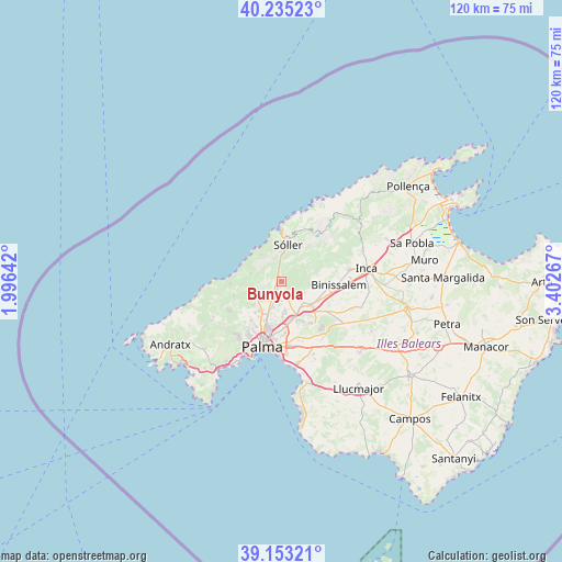
Bunyola GPS coordinates[2]
39° 41' 46.824" North, 2° 41' 58.38" East
| Map corner | latitude | longitude |
|---|---|---|
| Upper-left | 40.23523°, | 1.99642° |
| Center: | 39.69634°, | 2.69955° |
| Lower-right: | 39.15321°, | 3.40267° |
| Map W x H: | 120.3×120.3 km | = 74.8×74.8mi |
| max Lat: | 43.74134° ⇑74.5% North |
| Bunyola: | 39.69634° |
| min Lat: | ⇓25.5% South 27.64134° |
| min Long | Bunyola | max Long |
| -18.00367° | 2.69955° | 4.2899° |
| W 97.2%⇐ | ⇒2.8% E |
Elevation
Elevation of Bunyola is 217 m = 712 ft, and this is 381 m = 1250 ft below average elevation for this country.
| Max E: |
1682 m = 5518 ft | 80.2% |
| Avg. | 598 m = 1962 ft | |
| Bunyola | 217 m = 712 ft | |
Min E: |
0 m = 0 ft | 19.8% |
See also: Spain elevation on elevation.city.
Geographical zone
Bunyola is located in North temperate zone (between Tropic of Cancer and the Arctic Circle). Distance of this Northern Tropic circle is 1807.9 km =1123.4 mi to South.| Distance of | km | miles | from Bunyola |
|---|---|---|---|
| North Pole | 5593.2 | 3475.5 | to North |
| Arctic Circle | 2987.4 | 1856.3 | to North |
| Tropic Cancer | 1807.9 | 1123.4 | to South |
| Equator | 4413.8 | 2742.6 | to South |


Nearby cities:
15 places around Bunyola: (largest is in red/bold)
• Alaró
7.9 km =4.9 mi,  83°
83°
• Binissalem
12.4 km =7.7 mi,  94°
94°
• Consell
10.2 km =6.3 mi,  107°
107°
• Deià
7.2 km =4.5 mi,  322°
322°
• Es Molinar
15.1 km =9.4 mi,  187°
187°
• Esporles
10.8 km =6.7 mi,  253°
253°
• Fornalutx
10.2 km =6.3 mi,  20°
20°
• Lloseta
14.5 km =9 mi, 80°
• Marratxí
8.6 km =5.3 mi,  165°
165°
• Palma
14.7 km =9.1 mi,  196°
196°
• Port de Sóller
11.3 km =7 mi,  358°
358°
• Santa Eugènia
14.4 km =8.9 mi,  124°
124°
• Santa Maria del Camí
8.1 km =5 mi,  128°
128°
• Sóller
7.9 km =4.9 mi,  9°
9°
• Valldemossa
6.8 km =4.2 mi,  283°
283°
Sources, notices
• [Note1] Compared only with cities in Spain existing in our database
• [Src1] Map data: © OpenStreetMap contributors (CC-BY-SA)
• [Src2] Other city data from geonames.org with taken over terms of usage.
• [Src3] Geographical zone / Annual Mean Temperature by Robert A. Rohde @ Wikipedia
