Esporles geodata
Esporles (Balearic Islands) is a seat of a third-order administrative division; located in Spain in Europe/Madrid (GMT+2) time zone. With population of 4,457 people, there are 1392 cities with bigger population in this country. Compared to other cities in Spain, 74.8% of cities are located further ↑North; 96.8% of cities are located further ←West and 81.9% of cities have higher elevation than Esporles. Note1


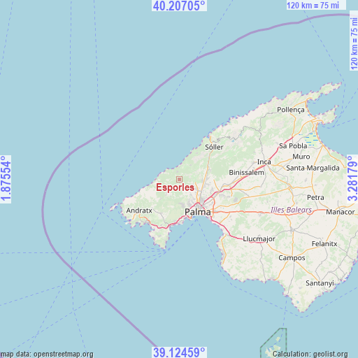
Esporles GPS coordinates[2]
39° 40' 4.584" North, 2° 34' 43.212" East
| Map corner | latitude | longitude |
|---|---|---|
| Upper-left | 40.20705°, | 1.87554° |
| Center: | 39.66794°, | 2.57867° |
| Lower-right: | 39.12459°, | 3.28179° |
| Map W x H: | 120.4×120.4 km | = 74.8×74.8mi |
| max Lat: | 43.74134° ⇑74.8% North |
| Esporles: | 39.66794° |
| min Lat: | ⇓25.2% South 27.64134° |
| min Long | Esporles | max Long |
| -18.00367° | 2.57867° | 4.2899° |
| W 96.8%⇐ | ⇒3.2% E |
Elevation
Elevation of Esporles is 188 m = 617 ft, and this is 410 m = 1345 ft below average elevation for this country.
| Max E: |
1682 m = 5518 ft | 81.9% |
| Avg. | 598 m = 1962 ft | |
| Esporles | 188 m = 617 ft | |
Min E: |
0 m = 0 ft | 18.1% |
See also: Spain elevation on elevation.city.
Geographical zone
Esporles is located in North temperate zone (between Tropic of Cancer and the Arctic Circle). Distance of this Northern Tropic circle is 1804.7 km =1121.4 mi to South.| Distance of | km | miles | from Esporles |
|---|---|---|---|
| North Pole | 5596.4 | 3477.4 | to North |
| Arctic Circle | 2990.5 | 1858.2 | to North |
| Tropic Cancer | 1804.7 | 1121.4 | to South |
| Equator | 4410.7 | 2740.7 | to South |


Nearby cities:
15 places around Esporles: (largest is in red/bold)
• Andratx
17 km =10.6 mi,  232°
232°
• Banyalbufar
5.9 km =3.7 mi,  291°
291°
• Bunyola
10.8 km =6.7 mi,  73°
73°
• Calvià
13 km =8.1 mi,  208°
208°
• Coll d'en Rabassa
16.4 km =10.2 mi,  142°
142°
• Deià
10.7 km =6.6 mi,  33°
33°
• Es Molinar
14.4 km =8.9 mi,  145°
145°
• Estellencs
8.5 km =5.3 mi,  259°
259°
• Marratxí
13.6 km =8.5 mi,  112°
112°
• Palma
12.6 km =7.8 mi, 150°
• Palmanova
16.3 km =10.1 mi,  191°
191°
• Puigpunyent
6.5 km =4 mi,  222°
222°
• Santa Maria del Camí
16.8 km =10.4 mi,  96°
96°
• Sóller
16 km =9.9 mi,  46°
46°
• Valldemossa
6 km =3.7 mi,  38°
38°
Sources, notices
• [Note1] Compared only with cities in Spain existing in our database
• [Src1] Map data: © OpenStreetMap contributors (CC-BY-SA)
• [Src2] Other city data from geonames.org with taken over terms of usage.
• [Src3] Geographical zone / Annual Mean Temperature by Robert A. Rohde @ Wikipedia
