Sóller geodata
Sóller (Balearic Islands) is a seat of a third-order administrative division; located in Spain in Europe/Madrid (GMT+2) time zone. With population of 13,942 people, there are 665 cities with bigger population in this country. Compared to other cities in Spain, 73.4% of cities are located further ↑North; 97.2% of cities are located further ←West and 91.9% of cities have higher elevation than Sóller. Note1


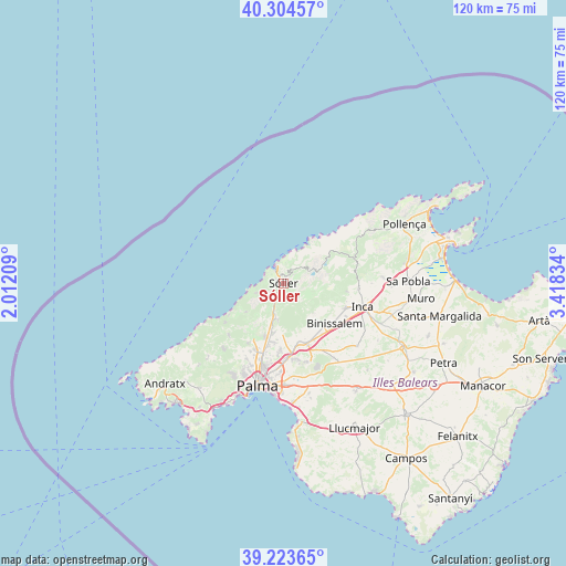
Sóller GPS coordinates[2]
39° 45' 58.428" North, 2° 42' 54.756" East
| Map corner | latitude | longitude |
|---|---|---|
| Upper-left | 40.30457°, | 2.01209° |
| Center: | 39.76623°, | 2.71521° |
| Lower-right: | 39.22365°, | 3.41834° |
| Map W x H: | 120.2×120.2 km | = 74.7×74.7mi |
| max Lat: | 43.74134° ⇑73.4% North |
| Sóller: | 39.76623° |
| min Lat: | ⇓26.6% South 27.64134° |
| min Long | Sóller | max Long |
| -18.00367° | 2.71521° | 4.2899° |
| W 97.2%⇐ | ⇒2.8% E |
Elevation
Elevation of Sóller is 45 m = 148 ft, and this is 553 m = 1814 ft below average elevation for this country.
| Max E: |
1682 m = 5518 ft | 91.9% |
| Avg. | 598 m = 1962 ft | |
| Sóller | 45 m = 148 ft | |
Min E: |
0 m = 0 ft | 8.1% |
See also: Spain elevation on elevation.city.
Geographical zone
Sóller is located in North temperate zone (between Tropic of Cancer and the Arctic Circle). Distance of this Northern Tropic circle is 1815.7 km =1128.2 mi to South.| Distance of | km | miles | from Sóller |
|---|---|---|---|
| North Pole | 5585.5 | 3470.7 | to North |
| Arctic Circle | 2979.6 | 1851.4 | to North |
| Tropic Cancer | 1815.7 | 1128.2 | to South |
| Equator | 4421.6 | 2747.5 | to South |


Nearby cities:
15 places around Sóller: (largest is in red/bold)
• Alaró
9.5 km =5.9 mi,  136°
136°
• Binissalem
14.1 km =8.8 mi,  128°
128°
• Bunyola
7.9 km =4.9 mi,  189°
189°
• Consell
13.7 km =8.5 mi, 142°
• Deià
6.1 km =3.8 mi,  250°
250°
• Escorca
14.5 km =9 mi,  65°
65°
• Esporles
16 km =9.9 mi,  226°
226°
• Fornalutx
2.8 km =1.7 mi,  51°
51°
• Lloseta
14 km =8.7 mi,  112°
112°
• Mancor de la Vall
13.6 km =8.5 mi,  97°
97°
• Marratxí
16.1 km =10 mi,  176°
176°
• Port de Sóller
3.8 km =2.4 mi,  335°
335°
• Santa Maria del Camí
13.7 km =8.5 mi,  158°
158°
• Selva
15.9 km =9.9 mi,  94°
94°
• Valldemossa
10.1 km =6.3 mi, 232°
Sources, notices
• [Note1] Compared only with cities in Spain existing in our database
• [Src1] Map data: © OpenStreetMap contributors (CC-BY-SA)
• [Src2] Other city data from geonames.org with taken over terms of usage.
• [Src3] Geographical zone / Annual Mean Temperature by Robert A. Rohde @ Wikipedia
