Marratxí geodata
Marratxí (Balearic Islands) is a seat of a third-order administrative division; located in Spain in Europe/Madrid (GMT+2) time zone. With population of 33,348 people, there are 271 cities with bigger population in this country. Compared to other cities in Spain, 75.4% of cities are located further ↑North; 97.3% of cities are located further ←West and 89.6% of cities have higher elevation than Marratxí. Note1


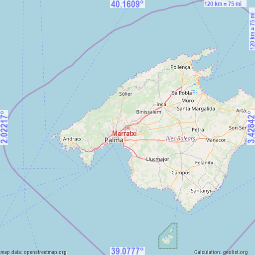
Marratxí GPS coordinates[2]
39° 37' 17.112" North, 2° 43' 31.08" East
| Map corner | latitude | longitude |
|---|---|---|
| Upper-left | 40.1609°, | 2.02217° |
| Center: | 39.62142°, | 2.7253° |
| Lower-right: | 39.0777°, | 3.42842° |
| Map W x H: | 120.4×120.4 km | = 74.8×74.8mi |
| max Lat: | 43.74134° ⇑75.4% North |
| Marratxí: | 39.62142° |
| min Lat: | ⇓24.6% South 27.64134° |
| min Long | Marratxí | max Long |
| -18.00367° | 2.7253° | 4.2899° |
| W 97.3%⇐ | ⇒2.7% E |
Elevation
Elevation of Marratxí is 72 m = 236 ft, and this is 526 m = 1726 ft below average elevation for this country.
| Max E: |
1682 m = 5518 ft | 89.6% |
| Avg. | 598 m = 1962 ft | |
| Marratxí | 72 m = 236 ft | |
Min E: |
0 m = 0 ft | 10.4% |
See also: Spain elevation on elevation.city.
Geographical zone
Marratxí is located in North temperate zone (between Tropic of Cancer and the Arctic Circle). Distance of this Northern Tropic circle is 1799.6 km =1118.2 mi to South.| Distance of | km | miles | from Marratxí |
|---|---|---|---|
| North Pole | 5601.6 | 3480.7 | to North |
| Arctic Circle | 2995.7 | 1861.4 | to North |
| Tropic Cancer | 1799.6 | 1118.2 | to South |
| Equator | 4405.5 | 2737.4 | to South |


Nearby cities:
15 places around Marratxí: (largest is in red/bold)
• Alaró
10.8 km =6.7 mi,  31°
31°
• Binissalem
12.5 km =7.8 mi,  54°
54°
• Bunyola
8.6 km =5.3 mi,  345°
345°
• Can Pastilla
9.5 km =5.9 mi,  183°
183°
• Coll d'en Rabassa
8.3 km =5.2 mi,  198°
198°
• Consell
9.1 km =5.7 mi, 54°
• Deià
15.5 km =9.6 mi,  334°
334°
• Es Molinar
7.9 km =4.9 mi,  212°
212°
• Esporles
13.6 km =8.5 mi,  292°
292°
• Palma
8.7 km =5.4 mi,  228°
228°
• Santa Eugènia
9.7 km =6 mi,  88°
88°
• Santa Maria del Camí
5.3 km =3.3 mi, 51°
• Sencelles
15 km =9.3 mi,  79°
79°
• Valldemossa
13.3 km =8.3 mi,  318°
318°
• s'Arenal
13.7 km =8.5 mi,  171°
171°
Sources, notices
• [Note1] Compared only with cities in Spain existing in our database
• [Src1] Map data: © OpenStreetMap contributors (CC-BY-SA)
• [Src2] Other city data from geonames.org with taken over terms of usage.
• [Src3] Geographical zone / Annual Mean Temperature by Robert A. Rohde @ Wikipedia
